Level-1 Products (Satellite measurements)
Level-0 to Level-1 processing is performed by ISRO. The Level-1 products consist of Brightness Temperature (MADRAS and SAPHIR) and of TOA Radiance (ScaRaB) along with geolocation, time of acquisition, and other relevant parameters and flags.Three types of Level-1 products will ultimately be disseminated to users, each corresponding to a different level of processing:
- The L1A product contains the instrument radiometric samples for all channels in scan mode (sensor geometry)
- The L1A2 product is an along-scan re-sampled version of L1A that provides non-overlapping pixels, in equal number in all channels
- The L1A3 product is the projection of L1A2 onto the 89GHz MADRAS Grid (i.e. MADRAS conical-scan sensor geometry)
For each of these 3 types of Level-1 products, 2 data-chunking schemes are applied that generate 2 types of files:
- Segments (S): sections of orbits, variable in size, possibly exceeding one full revolution, possibly redunding data over 2 segments (primarily for Near Real-Time use)
- Orbits (O): data chunks that match exactly one orbit (i.e. one revolution) from one ascending node to the next (standard product)
CNES and ISRO issued the Level-1 product definition for MADRAS, SAPHIR and ScaRaB, which includes the extended file naming convention of data products. CNES documents provide the Level-1 version history, a Summary on flags and a list of the mission incidents. Additionally, a summary of potential geolocation anomalies not detectable through quality flags is maintained and provided here. The Megha-Tropiques team issued the Megha-Tropiques Level 1 product handbook describing the mission and the products to ease the use of level 1 products.
Megha-Tropiques Level-1 products
| Retrieved parameter | Product Name | Product Type | Sensor | Spatial Resolution | No. of Overpasses | Distribution Status |
|---|---|---|---|---|---|---|
| Level-1 Megha-Tropiques Brightness Temperature and Radiance | Resp.: ISRO/CNES | |||||
| Brightness Temperature | MT1MADOL1A MT1MADOL1A2 | Orbit | MADRAS | 6 to 40 km | 1-6 times/day 28°S/28°N  | Public |
| MT1MADSL1A MT1MADSL1A2 | Segment | |||||
| Brightness Temperature | MT1SAPOL1A MT1SAPOL1A2 | Orbit | SAPHIR | 10 km at nadir | 1-6 times/day 28°S/28°N | Public |
| MT1SAPSL1A MT1SAPSL1A2 | Segment | |||||
| Filtered Radiance | MT1SCAOL1A MT1SCAOL1A2 | Orbit | ScaRaB | 40 km at nadir | 1-7 times/day 30°S/30°N | Public |
| MT1SCASL1A MT1SCASL1A2 | Segment | |||||
Level-2 and Level-4 Products (Geophysical parameters)
Four main product groups are generated from Megha-Tropiques Level-1 data, in combination with geostationary sensors for some of the products: Precipitation, Water Vapor, Radiation, and Cloud information.
- Level-2 and Level-4 Rain products: Level-2 « Instantaneaous precipitating conditions » products are generated from the MADRAS Level-1 data. The level-4 production involves the use of the geostationary data.
- Level-2 Water Vapor products, obtained in clear and cloudy but non-precipitating scenes, over land and ocean, include the Relative Humidity Profiles and the Upper Tropospheric Humidity derived from SAPHIR data
- Level-2 Radiative Budget products are derived from ScaRaB and include SW and LW outgoing fluxes at the top of the atmosphere and the albedo.
- Level-2 Cloud products such as cloud mask, cloud classification are produced solely from geostationary satellites as complementary data and are used in Level-2 algorithms.
The following tables list all the Megha-Tropiques products derived from science codes developped by the French science team at IPSL. The tables provide links to the product description and algorithm description (if available) and provide the expected date for product release.
Megha-Tropiques Level-2 science products
| Retrieved parameter | Product Name | Sensor | Spatial Resolution | No. of Overpasses | Distribution Status |
|---|---|---|---|---|---|
| Level-2 Precipitation (Instantaneous) | PI: N. Viltard (IPSL/LATMOS) | ||||
| Surface Rainfall Convective Rainfall Retrieval error Liquid Cloud content profile Liquid precipitation content profile Ice Cloud content profile Ice Precipitation content profile | L2-RAIN | MADRAS | 20 km | 1-6 times/day 28°S/28°N | Not public |
| Level-2 Water Vapor – Non precipitating conditions (Instantaneous) | PI: H. Brogniez (IPSL/LATMOS) | ||||
| Relative Humidity profile | L2-RH | SAPHIR | 10 km at nadir | 1-6 times/day 28°S/28°N | Public |
| Relative Humidity profile | L2B-RH | SAPHIR | 1 deg. | 1-6 times/day 28°S/28°N | Public |
| Upper Tropospheric Humidity | L2-UTH | SAPHIR | 10 km at nadir | 1-6 times/day 28°S/28°N | Public |
| Upper Tropospheric Humidity | L2B-UTH | SAPHIR | 1 deg. | 1-6 times/day 28°S/28°N | Public |
| Level-2 Radiative Budget (Instantaneous) | PI: O. Chomette (IPSL/LMD) | ||||
| LW, SW TOA outgoing fluxes Unfiltered Radiance Albedo | L2-FLUX | ScaRaB | 40 km at nadir | 1-7 times/day 30°S/30°N | Public |
| LW, SW TOA outgoing fluxes Albedo | L2B-FLUX | ScaRaB | 0.5 deg. and 1 deg. | 1-7 times/day 30°S/30°N | Public |
| Level-2 Geostationary Cloud Products (Based on SAFNWC algorithms) | PI: G. Sèze (IPSL/LMD) | ||||
| Cloud mask | GEOCLD_CMa SAFNWC_CMa | MSG,MTSAT, HIMAWARI, GOES-E, GOES-W | 3 or 4 km | every 15 or 30 min | Public |
| Cloud type classification | GEOCLD_CT SAFNWC_CT | MSG,MTSAT, HIMAWARI, GOES-E, GOES-W | 3 or 4 km | every 15 or 30 min | Public |
| Cloud top characterization | GEOCLD_CTTH SAFNWC_CTTH | MSG,MTSAT, HIMAWARI, GOES-E, GOES-W | 3 or 4 km | every 15 or 30 min | Public |
Megha-Tropiques Level-4 science products
| Retrieved parameter | Product Name | Sensor | Spatial Resolution | Composite Period | Distribution Status |
|---|---|---|---|---|---|
| Level-4 Surface accumulated rainfall | PI: R. Roca (OMP/LEGOS) | ||||
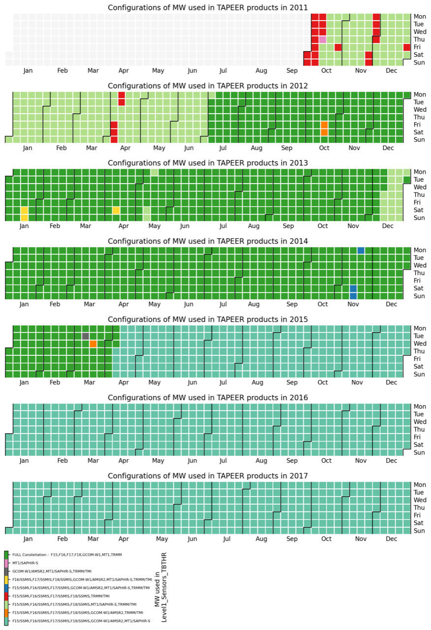
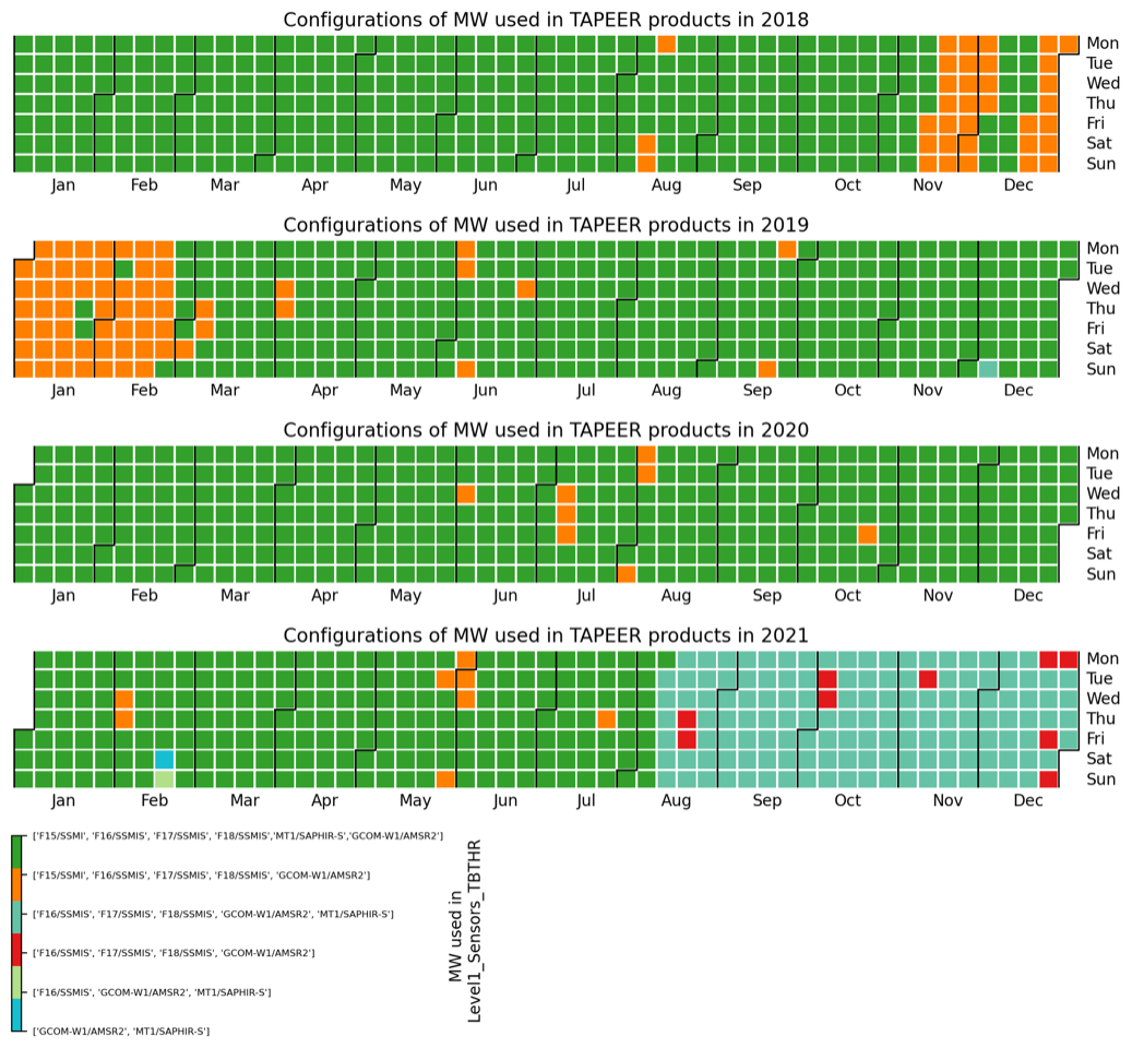
| Surface accumulated rainfall | L4-TAPEER-BRAIN | MT/SAPHIR, GCOMW1/AMSR-2, F15/SSMI,F16/SSMIS, F17/SSMIS,F18/SSMIS, TRMM/TMI,MFG,MSG, MTSAT,HIMAWARI, GOES-E,GOES-W | 1 deg | daily | Public |
Tapeer-Brain configuration summary
File Naming Convention
The level-2 and upper Megha-Tropiques products are made available in standard formats (HDF4, HDF5, or NetCDF, depending on product specifications).
MT1_<PRODUCT>-<PARENT PRODUCT>_<YYYY-MM-DDThh-mm-ss>_V<X-XX>.<extension>
<PRODUCT> = Level-2 and upper product name (Ex.: L2-UTH, L2-FLUX, L2B-FLUX)
<PARENT PRODUCT> = Level-1 parent product (including Level-1 version)
<YYYY-MM-DDThh-mm-ss> = Date of the first record (Year,Month,Day,hour,minute,second)
V<X-XX> = Product version
<extension> = hdf or nc file extension
Examples:
- MT1_L2-FLUX-SCASL1A2-1.06_2013-10-21T00-05-59_V1-00.hdf: Radiative TOA fluxes derived from SCARAB segment-wise Level-1A2 v1.06 product
- MT1_L2B-FLUX-SCASL1A2-1.06_2013-10-21T00-05-59_V1-00.nc: Radiative TOA fluxes derived from SCARAB segment-wise Level-1A2 v1.06 product
- MT1_L2-UTH-SAPSL1A2-1.06_2013-10-21T00-05-59_V1-00.hdf: Upper Tropospheric Humidity derived from SAPHIR segment-wise Level-1A2 v1.06 product
Version history
Currently, versions v1.06.7000, v1.07.8000 and v1.08.9000 of SAPHIR and ScaRaB Level-1A and Level-1A2 data products are distributed as Collection 2 in the ICARE Catalogue. Versions v1.05 and v1.06 of SAPHIR and ScaRaB Level-1A and Level-1A2 data products are assembled in Collection 1. Data products from earlier versions (v1.02, v1.03, v1.04) are assembled in Collection 0 (see table below for time periods).
Please note that this is the list of products that currently exist in the ICARE archive and that some of them are for evaluation only and not distributed to the public. See the catalogue for data availability.
This page is no longer available !
![]()