VolcPlume Portal
Project summary
The VolcPlume Portal (https://volcplume.aeris-data.fr) is dedicated to the near-real time and retrospective tracking and analysis of the physico-chemical properties of volcanic plumes in the atmosphere, from the source to regional/global scales. The portal allows for jointly analysing a broad panel of satellite and ground-based active and passive remote sensing observations of both volcanic gas and particles, as well as in-situ ground air quality monitoring measurements to detect and isolate a volcanic plume signature down to the ground. Benefiting from developments favouring interactivity and flexibility, this portal thus aims to facilitate an in-depth assessment of the multi-scale atmospheric impacts of volcanic plumes that can include, depending on the type and magnitude of the eruption, modifications of the atmospheric chemistry, degradation of air quality, aviation hazards, and climate impacts.
A complementary feature of the VolcPlume Portal allows for focusing on any active volcano in the world to determine, using remote sensing observations, temporal variations of gas and particle emissions from daily to annual timescales. Knowledge of the volcanic source, which is often highly variable with time, is indeed crucial for accurately initialising models of volcanic plume dispersion and robustly assessing atmospheric hazards. Regarding local volcanological hazards, this focus on emissions is also essential as it allows to remotely track changes in the degassing or eruptive activities of any isolated or non-instrumented volcano. In the event of a major eruption at a monitored volcano, satellite-based observations can also complement instruments deployed on the ground.
The VolcPlume interdisciplinary portal is relevant not only to the atmospheric science community but also to the earth science community, in particular volcanologists and volcanological observatories.
A broad panel of satellite, ground-based remote sensing and in situ observations
Satellite observations
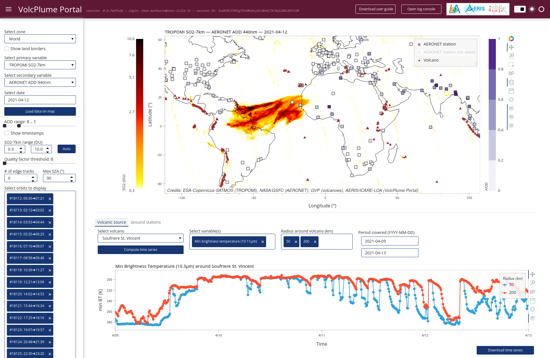
Currently, the portal integrates satellite measurements of both volcanic sulfur dioxide (SO2) gas and absorbing aerosols from polar low-Earth orbit (LEO) hyperspectral sensors such as Sentinel-5P/TROPOMI, MetOp/IASI, SUOMI-NPP/OMPS and Aura/OMI. In addition to column-integrated abundances, the height of SO2 and aerosol layers is also provided from MetOp/IASI and S5P/TROPOMI passive sensors respectively, as well as from active CALIPSO/CALIOP spaceborne lidar. Colocated information on cloud fraction is also available to assess any potential bias affecting the in-plume SO2 retrieval associated to the presence of meteorological clouds.
Complementary constraints on aerosol optical and absorption properties are also available from Aqua/MODIS and multi-directional polarimetric PARASOL/POLDER satellite imagery.
Information at a higher temporal resolution on SO2/particle abundance and altitude is also provided by integrating the suite of GOES, MSG and HIMAWARI geostationary (GEO) satellite imagers so as to achieve a worldwide coverage and detect any volcanic emission regardless of its geographical location on the globe. Hence, the VolcPlume Portal gives access to geostarionary-derived SO2/ash RGB products, plume brightness temperature at channels sensitive to ash particles, as well as cloud top aerosol height products that are developed within the EUMETSAT’s Nowcasting Satellite Application Facility (NWC SAF) context.
Ground-based remote sensing and in situ observations
One of the original features of the VolcPlume Portal is to allow users to perform a joint and interactive analysis of a variety of satellite observations together with measurements from various networks of ground stations. Ground data include remote sensing observations by solar and lunar photometry of the international AERONET network (AErosol RObotic NETwork) that provide the columnar optical, microphysical and radiative properties of aerosols. The vertical distribution of aerosols and their geometrical shape are also explored through active remote sensing observations from LIDAR stations of SNO PHOTONS/LIDAR and NDACC (components of ACTRIS-FR) as well as Meteo France networks. Finally, time series of ground mass concentrations in SO2 and particulate matter from French air quality monitoring networks helps detecting potential excess concentrations associated to the presence of volcanic gas and particulate compounds at the ground level. A multi-station analysis can also be extracted to compare the temporal evolution of selected parameters among several measurement stations of interest.
Portal section focusing on emissions
The portal offers the possibility to zoom in on any active volcano, displaying either a persistent or eruptive degassing activity, to determine from TROPOMI satellite observations the variations of the daily SO2 mass emissions over week to year timescales. Assuming a given altitude of SO2 injection, the mass budget is calculated by interpolating on a regular grid the SO2 column amount maps for selected pixels and then integrating the SO2 mass within a disk centred on the volcano whose radius is chosen by the user. Integration over a circular domain allows indeed for compensating cross-plume diffusion, without requiring prior knowledge of the direction of plume transport. Timeseries of the mean TROPOMI cloud fraction within the same disk area allows for assessing any potential bias affecting the SO2 mass burden timeseries related to meteorological conditions.
Furthermore, the top altitude of aerosol-rich emissions over the volcanic source, as well as associated pressure and temperature conditions, are estimated from geostationary observations approximately two hours after acquisition. ECMWF ERA5 reanalysis and forecast data (wind field at all pressure levels) can also be displayed along with satellite products to assist in the evaluation of the direction and altitude of a drifting plume in the hours following emission.
Data policy
If you use the VolcPlume Portal in your research, please include in your publications a mention or acknowledgment along with the following reference: Boichu, M. & Mathurin, T. (2022). VolcPlume Portal. [InteractiveResource]. AERIS. https://doi.org/10.25326/362.
The AERIS/ICARE data policy also applies.
Funding
A prototype of the VolcPlume Portal has been initially developed at the Laboratoire d’Optique Atmosphérique (LOA, Université de Lille) in collaboration with C. Deroo and C. Brogniez, within the framework of the VOLCPLUME project funded by the French National Research Agency (ANR-15-CE04-0003) and coordinated by Marie Boichu. The portal has then been taken up and further developed in collaboration with the AERIS/ICARE Data and Services Centre.