Products
Description
The main variable of this product is a features categorisation mask, with :
- a vertical resolution of 60m between [ -1.02 km , 25.08 km ]
- colocated with the CLOUDSAT footprints ( ~1.1 km )
It also contains many variables extracted from the CALIPSO and CLOUDSAT products, sampled or interpolated to the DARDAR resolution.
Naming convention
DARDAR-MASK_v<Version>_<Timestamp>_<Granule>.hdf
<Version> | A 3 digits dot separated version number as X.X.X |
<Timestamp> | The timestamp of the orbit, using the CLOUDSAT format YYYYJJJHHMMSS, Year, Julian day, hour, minute, second of the first data contained in the file (UTC) |
<Granule> | The granule number, on 5 digits |
Examples
Product | Parametres | Download |
---|---|---|
DARDAR-MASK |
– Cloud and Aerosols advanced Feature Mask – Simplified categorisation | DARDAR-MASK_v1.1.4_2009001021530_14253.hdf |
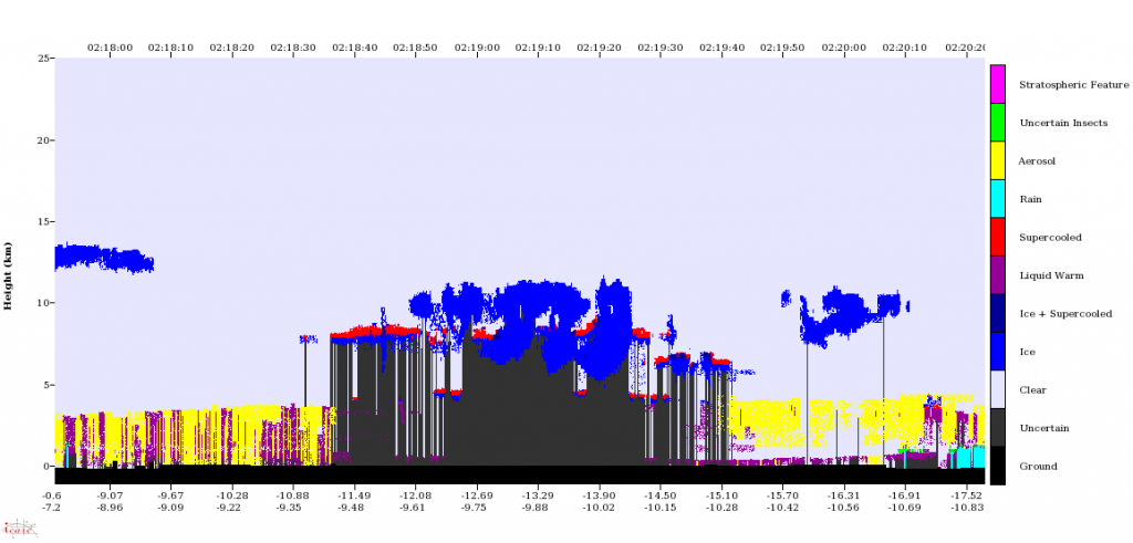
DARDAR-MASK Browse | The full orbit quick-look of the simplified categorisation | DARDAR-MASK_v1.1.4_2009001021530_14253 Simplified_Categorization.png |
Variables
Description
Name | Description | Unit | Type | Fill | Comments |
---|---|---|---|---|---|
CS_TRACK_Height | Height of range bin | km | float32 | Height of range bin above reference surface (~ mean sea level) | |
CLOUDSAT_UTC_Time | Radar Footprint UTC time | s | float32 | Seconds since the start of the granule UTC | |
Layer_Number | Indice of the layer, for layer integrated variables | None | int8 | ||
CLOUDSAT_TAI_Time | Radar Footprint TAI time | s | float64 | Seconds since the start of the granule TAI | |
CLOUDSAT_Latitude | Latitude of the colocated product | degrees | float32 | ||
CLOUDSAT_Longitude | Longitude of the colocated product | degrees | float32 | ||
CLOUDSAT_Radar_Frequency | Radar Frequency | GHz | float32 | Frequency of the CloudSat Radar | |
CLOUDSAT_2B_GEOPROF_Radar_Reflectivity | Radar Reflectivity at 94GHz (must be divided by 100) | dBZ | int16 | -8888 | Radar Reflectivity at 94GHz (must be divided by 100) |
CLOUDSAT_2B_GEOPROF_CPR_Gaseous_Attenuation | Gaseous Attenuation must be divided by 100 | dBZ | int16 | -9999 | Gaseous Attenuation must be divided by 100 |
CLOUDSAT_2B_GEOPROF_CPR_Cloud_Mask | CloudSat cloud mask | None | int8 | -9 | Each CPR resolution volume is assigned 1 bit mask value 0=No cloud detected 1=likely bad data 5=likely ground clutter 5-10=week detection found using along track integration 20 to 40=Cloud detected .. increasing values represents clouds with lower chance of a being a false detection |
CLOUDSAT_1B_CPR_Sigma-Zero | The Sigma-Zero is the normalized surface cross section (must be divided by 100) | None | int16 | -9999 | The Sigma-Zero is the normalized surface cross section (not corrected for attenuation) from CloudSat |
CLOUDSAT_Random_Measurement_Error | Random Measurement Error in Radar Reflectivity at 94GHz | dBZ | float32 | -9999.0 | |
CALIOP_Profile_Time | Profile time of the first and the last LIDAR shot averaged in the RADAR footprint | secs | float64 | -inf | TAI93 time convention |
CALIOP_Lidar_Wavelength | Lidar wavelength | nm | float32 | Wavelength of the Calipso lidar | |
CALIOP_Lidar_Telescope_Field_Of_View | Lidar telescope field of view | microrad | float32 | Field of view of the Calipso lidar | |
CALIOP_Lidar_Beam_Divergence | Lidar beam divergence | microrad | float32 | Lidar beam divergence of the Calipso lidar | |
CALIPSO_Spacecraft_Altitude | Altitude of the CALIPSO satellite above reference surface (~ mean sea level) | None | float32 | km | |
CLOUDSAT_CALIOP_Colocation_Distance | Distance between radar and lidar footprints | km | float32 | -9999.0 | |
CALIOP_Total_Attenuated_Backscatter_532 | CALIOP Total Attenuated backscatter at 532nm | m-1 sr-1 | float32 | -9999.0 | New height resolution (60m) |
CALIOP_Parallel_Attenuated_Backscatter_532 | CALIOP Parallel Attenuated backscatter at 532nm | m-1 sr-1 | float32 | -9999.0 | New height resolution (60m) |
CALIOP_Perpendicular_Attenuated_Backscatter_532 | CALIOP Perpendicular Attenuated backscatter at 532nm | m-1 sr-1 | float32 | -9999.0 | New height resolution (60m) |
CALIOP_Total_Backscatter_532_Random_Error | Random measurement error in Total Attenuated backscatter | m-1 sr-1 | float32 | -9999.0 | |
CALIOP_Land_Water_Mask | Land Water Mask from Calipso files | None | int8 | -9 | Land Water Mask from Calipso files, indicating the surface type at the laser footprint 0=shallow ocean 1=land 2=coastlines 3=shallow inland water 4=intermittent water 5=deep inland water 6=continental ocean 7=deep ocean |
CALIOP_IGBP_Surface_Type | IGBP Surface Type from Calipso files | None | int8 | -9 | International Geosphere Biosphere Programme Global Land Cover types at the laser footprint http://www-surf.larc.nasa.gov/surf/pages/sce_type.html 1=Evergreen Needleleaf Forest 2=Evergreen Broadleaf Forest 3=Deciduous Needleleaf Forest 4=Deciduous Broadleaf Forest 5=Mixed Deciduous Forest 6=Closed Shrubland 7=Open Shrubland 8=Woody Savanna 9=Savanna 10=Grassland 11=Permenant Wetland 12=Cropland 13=Urban 14=Crop/Natural Veg. Mosaic 15=Permanent Snow/Ice 16=Barren/Desert 17=Water Bodies 18=Tundra 19=Fresh Snow 20=Sea Ice |
CALIOP_Day_Night_Flag | Day Night Flag for lidar Night (1) Day (0) | None | int8 | ||
Surface_pressure | Surface Pressure from ECMWF model | Pa | float32 | -999.0 | |
Skin_temperature | Skin Temperature from ECMWF model | K | float32 | -999.0 | |
Temperature_2m | Two-meter temperature from ECMWF model | K | float32 | -999.0 | |
Tropopause_Height | Tropopause Height from CAL_LID_L1, averaged in the RADAR spot | km | float32 | ||
CLOUDSAT_Cloud_Scenario | CLOUDSAT 2B-CLDCLASS Cloud Scenario | None | int8 | -99 | Bits [0,1,2,3] of the CLOUDSAT 2B-CLDCLASS Cloud Scenario No cloud 0 Cirrus 1 Altostratus 2 Altocumulus 3 St 4 Sc 5 Cumulus 6 Deep Convection 7 Ns 8 |
CLOUDSAT_Precipitation_Flag | CLOUDSAT 2B-CLDCLASS Precipitation Flag | None | int8 | -99 | Bits [13,14] of the CLOUDSAT 2B-CLDCLASS Cloud Scenario no precipitation 0 liquid precipitation 1 solid precipitation 2 possible drizzle 3 |
Temperature | Temperature from ECMWF model | K | float32 | -999.0 | Temperature from ECMWF model interpolated on DARDAR heights |
Pressure | Pressure from ECMWF model | Pa | float32 | -999.0 | Pressure from ECMWF model interpolated on DARDAR heights |
Specific_humidity | Specific humidity from ECMWF model | None | float32 | -999.0 | Specific humidity from ECMWF model interpolated on DARDAR heights |
Ozone | Ozone mixing ratio from ECMWF model | None | float32 | -999.0 | Ozone mixing ratio from ECMWF model interpolated on DARDAR heights |
CALIPSO_Mask | New mask from calipso L2 vertical feature mask | None | int8 | -99 | sub surface m=-1 surfarce m=0 no signal m=1 molecular m=2 cloud good m=3 cloud med m=4 cloud bad m=5 cloud none m=6 aerosol good m=7 aerosol med m=8 aerosol bad m=9 aerosol none m=10 stratospheric feature m=11 |
MODIS_Channel | MODIS Radiances Channel index | None | int8 | ||
MODIS_Wavelength | MODIS Radiances Channel wavelength | None | float32 | microns | |
MODIS_Radiance | Radiances at the top of the Atmosphere from Modis | W m-2 um-1 sr-1 | float32 | -999.0 | Radiances (29-31-32) at the top of the Atmosphere from Modis |
MODIS_Radiance_Uncert | Uncertainties Indexes from Modis | % | float32 | -999.0 | Uncertainties Indexes from Modis |
MODIS_Solar_zenith | Solar zenith angle for MODIS pixel ( must be divided by 100 ) | degrees | int16 | -32767 | Solar zenith angle for MODIS central pixel ( must be divided by 100 ) |
MODIS_Solar_azimuth | Solar azimuth angle for MODIS pixel ( must be divided by 100 ) | degrees | int16 | -32767 | Solar azimuth angle for MODIS central pixel ( must be divided by 100 ) |
MODIS_Sensor_zenith | Sensor zenith angle for MODIS pixel ( must be divided by 100 ) | degrees | int16 | -32767 | Sensor zenith angle for MODIS central pixel ( must be divided by 100 ) |
MODIS_Sensor_azimuth | Sensor azimuth angle for MODIS pixel ( must be divided by 100 ) | degrees | int16 | -32767 | Sensor azimuth angle for MODIS central pixel ( must be divided by 100 ) |
IIR_Channel_Wavelength | CALIPSO IIR Channels Wavelength | microns | float32 | ||
IIR_Radiance | IIR calibrated radiances for each channel | Watts per square meter per steradian per micron | int16 | -9999 | |
IIR_Viewing_Zenith_Angle | IIR viewing zenith angle for each channel | degrees | int16 | -9999 | |
IIR_Viewing_Azimuth_Angle | IIR viewing azimuth angle for each channel | degrees | int16 | -9999 | |
CALIOP_Mask_Refined | New feature mask derived from the RADAR and the LIDAR signals | None | int8 | -99 | ground=-1 no signal=0 molecular=1 nuage=2 aerosol=3 strato=4 unsel=5 |
Warm_Cold_Pixel | Warm/Cold Pixels Indices | None | int8 | -1 | Flag identifying the phase of the cloudy bin – Intermediate Variable -1 -> Invalid 0 -> Water 1 -> Ice |
Lidar_Gates | Profiles Mask that identifies the cloud layers | None | int8 | -1 | Vertical resolution : 60m |
Warm_Layer_Mask | Profiles Mask that identifies the Warm cloud bins | None | int8 | -1 | Vertical resolution : 60m |
Layer_Temperature | Temperature integrated layer by layer | K | float32 | -9999 | |
Layer_Radar_Reflectivity | CLOUDSAT Radar Reflectivity integrated layer by layer | dBZe | float32 | -9999 | |
Layer_Perpendicular_Attenuated_Backscatter_532 | Total Perpendicular LIDAR Backscatter 532 integrated layer by layer | sr-1 | float32 | -9999.0 | |
Layer_Parallel_Attenuated_Backscatter_532 | Total Parallel LIDAR Backscatter 532 integrated layer by layer | sr-1 | float32 | -9999.0 | |
Layer_Total_Attenuated_Backscatter_532 | Total Total LIDAR Backscatter 532 integrated layer by layer | sr-1 | float32 | -9999.0 | |
Layer_Lidar_Ratio | Lidar Ratio (Beta Perp / Beta Para) integrated layer by layer | None | float32 | -9999.0 | |
CLOUDSAT_Ground_Mask | Mask issued of the RADAR signal that identifies the ground | None | int8 | -1 | -1 -> Invalid 0 -> No Ground 1 -> Ground |
CLOUDSAT_No_Data_Mask | Mask issued of a combination of the RADAR and LIDAR signals that identifies the profiles that have no data | None | int8 | -1 | -1 -> Invalid 0 -> Data 1 -> No Data |
CLOUDSAT_Unknown_Lidar_Mask | Mask that flags the bins where the feature can’t be retrieved by the LIDAR | None | int8 | -1 | |
CLOUDSAT_Target_Radar_Mask | RADAR instrument flags | None | int8 | -1 | -1 -> Unknown 0 -> Background Noise 1 -> Good Signal -2 -> Clutter -9 -> Ground |
CLOUDSAT_Target_Lidar_Mask | LIDAR instrument flags | None | int8 | -1 | -1 -> Unknown 0 -> Molecular 1 -> Cloud, Aerosol or Stratospheric Feature -9 -> Ground |
DARMASK_Ice | DARMASK Ice Feature Flags | None | int8 | -1 | -9 -> ground -1 -> don’t know 0 -> no 1 -> yes 2 -> Stratospheric Feature |
DARMASK_Rain | DARMASK Rain Feature Flags | None | int8 | -1 | -9 -> ground -2 -> clutter -1 -> don’t know 0 -> none 1 -> yes |
DARMASK_Liquid | DARMASK Liquid Feature Flags | None | int8 | -1 | -9 -> ground -1 -> don’t know 0 -> no 1 -> warmed 2 -> supercooled 3 -> warm in RADAR clutter and ice above |
DARMASK_Aerosol | DARMASK Aerosol Feature Flags, directly read from LIDAR mask | None | int8 | -1 | -9 -> ground -1 -> don’t know 0 -> none 1 -> yes |
DARMASK_Insect | DARMASK Insect Feature Flags | None | int8 | -1 | -9 -> ground -1 -> don’t know 0 -> none 1 -> Maybe |
DARMASK_Simplified_Categorization | Simplified DARMASK Categorization Flags | None | int8 | -1 | -9 -> ground -1 -> don’t know 0 -> clear 1 -> ice 2 -> ice + supercooled 3 -> liquid warm 4 -> supercooled 5 -> reain 6 -> aerosol 7 -> maybe insects 8 stratospheric feature |
Calibration
Some of the variables are stored as integers for saving disk space. For each variable, the user will find 2 standard SDS attributes called « scale_factor » and « add_offset ». Most of time, the standard HDF formula for scaling raw file values to physical ones is used :
science_value = ( raw_value – add_offset ) * scale_factor
Nevertheless, when a non standard scaling equation is used, this will be specified in a SDS attribute called « scaling_equation ».