Megha-Tropiques is a joint mission between the French (CNES) and Indian (ISRO) space agencies to study the water cycle and energy exchange in the tropical atmosphere. The expected life span of the satellite is 3 to 5 years.
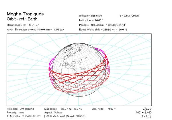
Due to its original instrument combination and its specific orbit, Megha-Tropiques provides unprecedented atmospheric observations in the equatorial region with a high temporal sampling. Indeed, thanks to its circular orbit at a 20° inclination to the equator, Megha-Tropiques can sample the equatorial region (up to about ±30º) up to seven times daily, an important capability to follow life cycle of the mesoscale convective systems and their rapid evolution. The figure shows the orbit tracks of one day (more details on the Megha-Tropiques Science web site).
The scientific objectives of the mission are:
- Atmospheric energy budget in the intertropical zone and at system scale (radiation, latent heat, etc.)
- Life cycle of Mesoscale Convective Systems in the Tropics (over Oceans and Continents)
- Monitoring and assimilation for Cyclones, Monsoons, Mesoscale Convective Systems forecasting
In France and in India, science teams define the science objectives, the instruments characteristics and validate the products. In France, a number of CNRS/INSU laboratories are part of this science team: LMD, LATMOS and LOCEAN from IPSL and CNRM, LAMP, LERMA, IGE, GET, and GSMA. The Principal Investigator of the French science team is Rémy Roca (LEGOS). He is responsible for all the scientific activities related to the mission and he chairs the Mission Advisory Group which gathers representatives of the involved laboratories, CNES, METEO-FRANCE and IRD. The Megha-Tropiques science objectives are naturally geared toward those of the Global Energy and Water cycle EXperiment (GEWEX). In addition, Megha-Tropiques is the first satellite launched as a component of the Global Precipitation Measurement (GPM) constellation initiated by NASA and JAXA as a global successor of TRMM. In this context, NASA, CNES and ISRO have signed a series of cooperative agreements on the GPM datasets and science activities.
The satellite was launched by ISRO on October 12, 2011. Information on the launch vehicle and the Megha-Tropiques payload can be found in the brochure (source ISRO).
Instruments
Megha-Tropiques carries four instruments:
- The MADRAS microwave imager, the mission’s main instrument, designed to measure precipitation and cloud characteristics,
- The SAPHIR microwave radiometer sounder , for producing vertical profiles of water vapor in the atmosphere,
- The SCARAB broadband optical radiometer, for measuring radiation fluxes at the top of the atmosphere,
- The GPS radio-occultation receiver, for determining atmospheric temperature and humidity.
A description of the instruments is available on the CNES Megha-Tropiques web site.
| Instrument | Agency | Main Instrument Features | Main Science Applications |
|---|---|---|---|
| MADRAS Microwave Analysis and Detection of Rain and Atmospheric Structures | ISRO and CNES | 5 Spectral bands with H/V polarization:18.7 (H+V), 23.8 (V), 36.5 (H+V), 89 (H+V) and 157 (H+V) GHz Spatial Resolution: 6 to 40 km Scan Geometry: conical Swath Width: 1700 km | Precipitation, cloud characteristics |
| SAPHIR Sounder for Probing Vertical Profiles of Humidity | CNES | 6 Spectral bands: within the 183.31 GHz +/-11 GHz water vapor absorption Spatial Resolution: 10 km at nadir Scan Geometry: cross-track Swath Width: 1700 km | Vertical Profile of Water Vapor |
| ScaRaB Scanner for Radiation Budget | CNES | 4 Spectral bands: 0.5-0.7 µm; 0.2-4 µm; 0.2-50 µm; 10.5-12.5 µm Spatial Resolution: 40 km at nadir Scan Geometry: cross-track Swath Width: 2200 km | Radiative Budget |
| ROSA Radio Occultation Sensor | ISRO | Temperature and humidity profiles |