Measuring the size of stratospheric aerosols from volcanic eruptions
Explosive eruptions can inject massive amounts of sulfate aerosols in the stratosphere, that are capable of perturbing atmospheric chemistry and Earth’s climate. However, crucial information about the size of aerosols, a critical parameter in climate models, is generally missing. To address such gap, an interdisciplinary team from LOA (Laboratoire d’Optique Atmosphérique) at the University of Lille, in collaboration with IPGP (Institut de Physique du Globe de Paris) and AERIS/ICARE National Data and Services Center has recently developed a novel method of analysis of AERONET (AErosol RObotic NETwork) ground-based remote sensing measurements. Synergy with various Low Earth Orbit (TROPOMI, IASI), geostationary (HIMAWARI-8/AHI) and active LIDAR (CALIOP) satellite observations, has allowed for tracking the growth and multi-year global persistence of stratospheric sulfate aerosols from the record-breaking eruption of Hunga Tonga-Hunga Ha’apai in the satellite era (Boichu et al., JGR 2023).
Thanks to the coverage of the worldwide open-access AERONET network of sun/sky/lunar photometers, the team provides, with improved spatial and temporal resolutions, the size distribution of sulfate aerosols, which are often larger in size than background fine particles. Hence, our new method allows for separating the signature of volcanic aerosols from those of background particles coexisting in the atmospheric column. This makes it possible to identify volcanic sulfate aerosols and accurately describe their microphysical and absorption properties, as a function of plume age, for timescales ranging from days to years.
The synergistic analysis of satellite and ground-based observations, as well as multi-station data analysis, was performed using the AERIS VOLCPLUME web portal (Boichu & Mathurin, 2022). This interactive portal, dedicated to the tracking and analysis of the 4D physico-chemical properties of volcanic plumes in the atmosphere, from source to global scales, was used in crisis time to deliver information on Hunga Tonga aerosols (Lac et al. 2022).
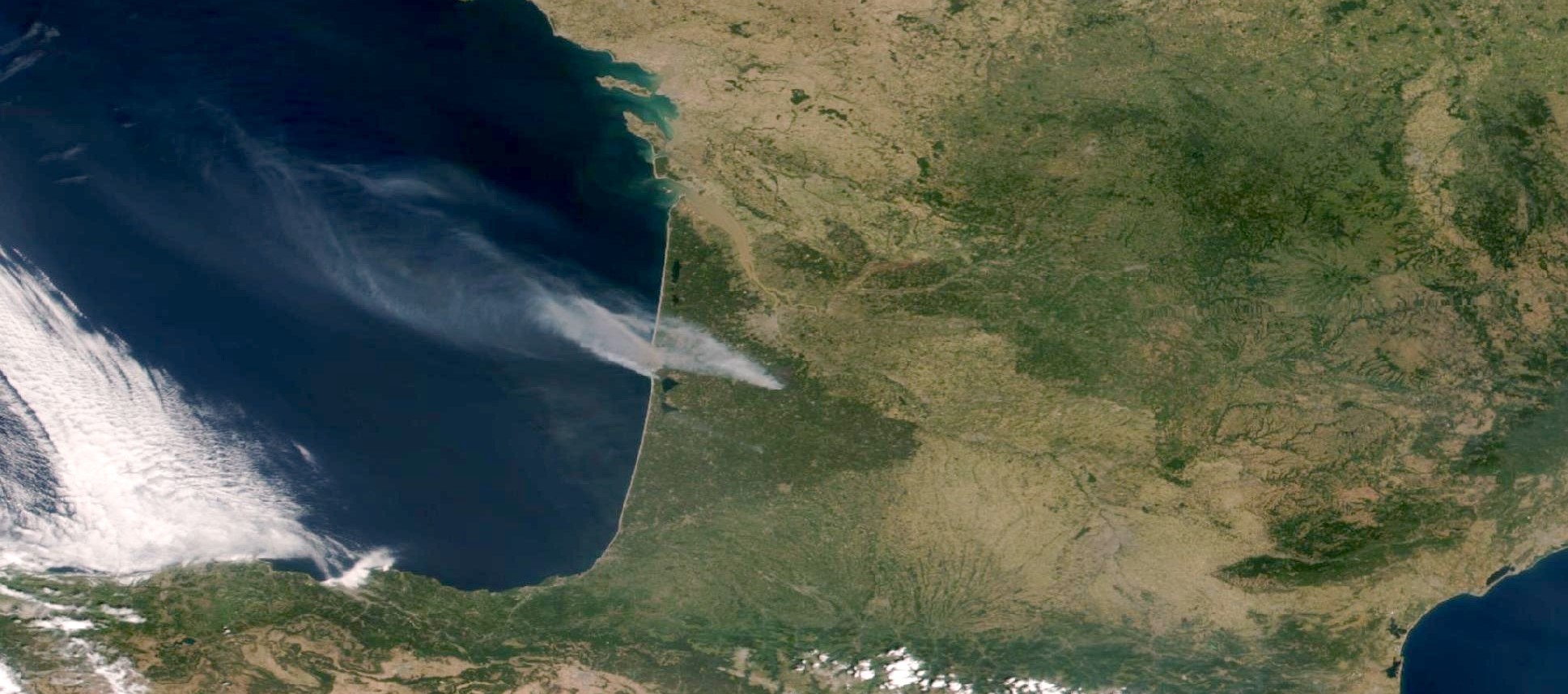
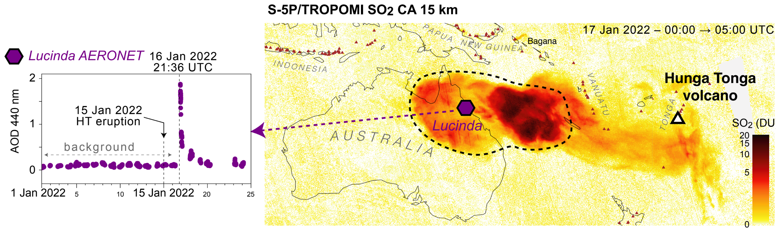
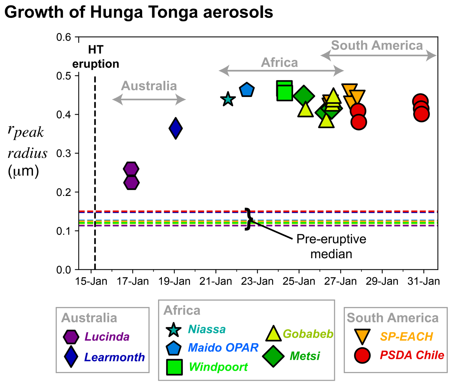
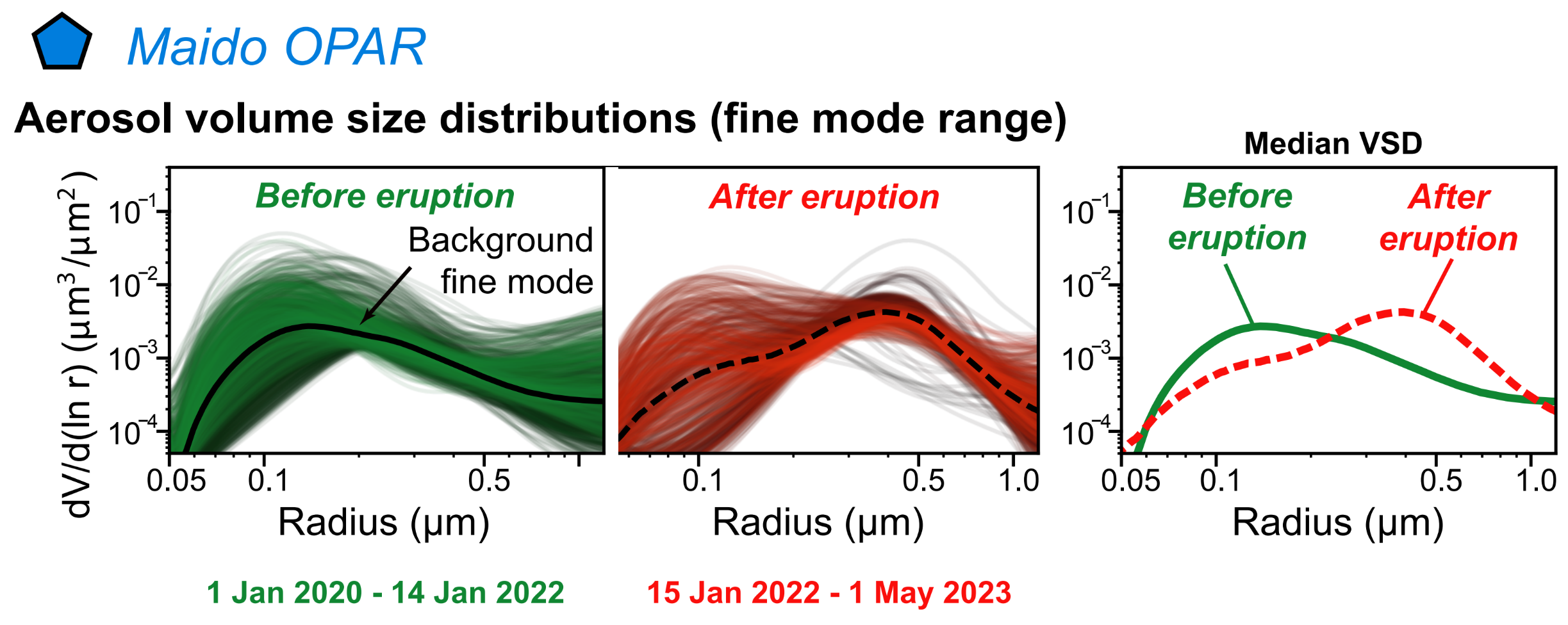
First, the team documented a rapid growth of Hunga Tonga (HT) sulfate aerosols in the days following eruption, almost doubling in size over their 7-days transport from eastern Australia (Fig. 1) to La Réunion (Fig. 2). AERONET measurements from the ACTRIS stations of Maido OPAR on La Réunion Island in the Indian Ocean and Gobabeb in Namibia (Fig. 2), played an important role to constrain such early aerosol growth, that is shown to be faster than observed for 1991 Pinatubo. This high aerosol growth rate is interpreted as the result of the exceptional humidification of the stratosphere caused by the water-rich HT eruption.
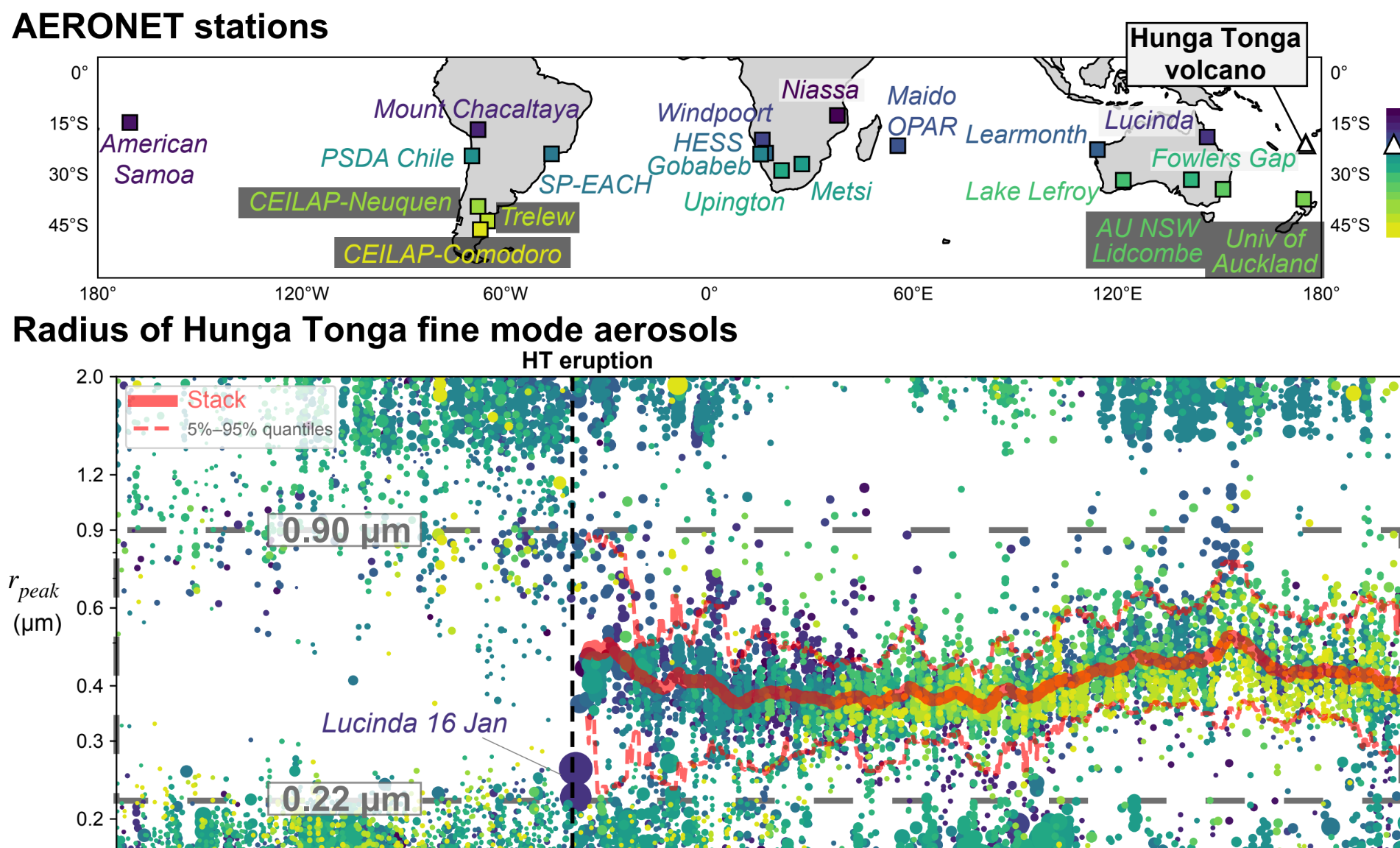
A year-long persistence of HT fine type of aerosols (i.e. with a peak radius in 0.3-0.5 μm) was identified at 20 AERONET stations of the southern hemisphere (Figures 3 and 4). Hence, the team tracked, at high spatial and temporal resolutions, the dispersion of HT sulfate aerosols toward the South Pole region and their size (Fig. 4). It took four months for the plume to reach high latitudes south of 43°S.
More than one year after eruption, and in spite of an initially rapid growth, HT sulfate aerosols remain smaller than Pinatubo particles. Smaller particles better reflect sunlight and remain in suspension in the stratosphere for a longer time, fostering surface cooling, but their effect on Earth’s radiative balance is modulated by their lifetime and abundance, which remain uncertain. Following the spatial and temporal evolution of Hunga Tonga aerosols in the coming years may help scientists to determine the net impact of this exceptional eruption on Earth’s climate.
Contact : Marie Boichu, CNRS/Université de Lille, Laboratoire d’Optique Atmosphérique (LOA) (marie.boichu@univ-lille.fr)

References
- Boichu, M., Grandin, R., Blarel, L., Torres, B., Derimian, Y., Goloub, P., Brogniez, C., Chiapello, I., Dubovik, O., Mathurin, T., Pascal, N., Patou, M., & Riedi, J. (2023), “Growth and global persistence of stratospheric sulfate aerosols from the 2022 Hunga Tonga-Hunga Ha’apai volcanic eruption”. Journal of Geophysical Research : Atmosphere, , 128, e2023JD039010, https://doi.org/10.1029/2023JD039010
- Boichu, M. and Mathurin, T. (2022). VOLCPLUME, an interactive web portal for the multiscale analysis of volcanic plume physico-chemical properties [Interactive Web based Ressource], AERIS, https://doi.org/10.25326/362, Portal access: https://volcplume.aeris-data.fr, Website address: https://www.icare.univ-lille.fr/volcplume/
- Lac, C., Le Pichon, A., Listowski, C., Abbassi, G., Astafyeva, E., Baron, A., Berveiller, D., Boichu, M., Clerbaux, C. et al. (2022). “The eruption of the Hunga Tonga – Hunga Ha’apai volcano on January 15, 2022: a shock of the Earth on a global scale” (Tech. Rep.). Groupe Thématique Atmosphère d’ALLENVI. https://zenodo.org/record/7678770/files/Tonga_FR_FINALE_DOI_v1.1.pdf, doi: https://doi.org/10.5281/zenodo.7678770
Related articles:
1- Communication ACTRIS-EU: https://www.actris.eu/news-events/news/measuring-size-stratospheric-aerosols-volcanic-eruptions
2- Communication DATA TERRA: https://www.data-terra.org/actualite/mesure-de-la-taille-des-aerosols-stratospheriques-provenant-deruptions-volcaniques/
3- Communication CNRS Hauts de France, 7 December 2023, “Mesurer la taille des aerosols stratosphériques, un paramètre clé pour comprendre leur impact sur le climat”: https://www.hauts-de-france.cnrs.fr/fr/cnrsinfo/mesurer-la-taille-des-aerosols-stratospheriques-un-parametre-cle-pour-comprendre-leur