THE ERUPTION OF PITON DE LA FOURNAISE OBSERVED BY THE WEB PLATFORM VOLCPLUME

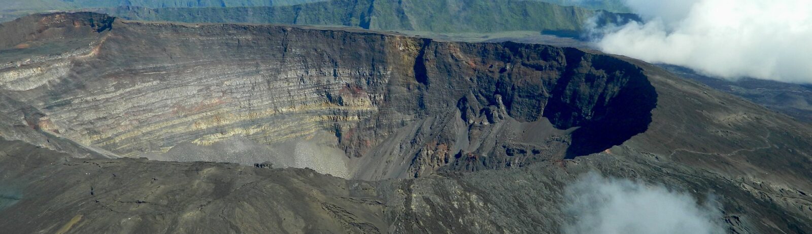
The Piton de la Fournaise, reaching an altitude of 2,632 metres, is the active volcano on the island of Reunion in the Indian Ocean. Piton de la Fournaise is one of the most active volcanoes on the planet: in terms of the frequency of new eruptions (on average one every nine months over the last ten years), and in terms of the average volume of lava emitted, it is about ten times less productive than Kīlauea, but comparable to Etna. Since the end of 1979, the activity of Piton de la Fournaise has been monitored and followed by the Observatoire Volcanologique du Piton de la Fournaise (OVPF), one of the volcanological observatories of the Institut de Physique du Globe de Paris (IPGP).

On September 19th, the Piton de la Fournaise erupted again.

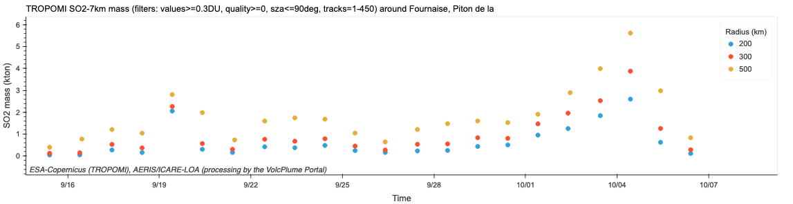
The VolcPlume observation platform, developed by the Laboratoire d’Optique Atmosphérique (University of Lille) in collaboration with the AERIS/ICARE Data and Services Centre, makes it possible to monitor volcanic emissions and plumes in the atmosphere thanks to a combination of data from satellites and networks of ground-based measurement stations. Using Sentinel-5P/TROPOMI satellite observations developed within the framework of the Copernicus atmospheric monitoring programme, scientists were able to describe the evolution of sulphur dioxide (SO2) degassing activity associated with the effusive activity of Piton de La Fournaise, which reached its highest intensity on 4 October 2022 (Fig 1). A sharp drop in the outgassing of Piton de La Fournaise is then observed, coinciding with the cessation of the seismic signal called “eruptive tremor”, recorded on the morning of 5 October by the Observatoire Volcanologique du Piton de La Fournaise, which indicates the cessation of lava emissions at the surface. Indeed, from October 6, 2022, a level of degassing is recorded reaching values similar to those recorded before the start of the eruption.

Figure 1A: Dispersion of the SO2-rich plume from Piton de la Fournaise, an active volcano on Reunion Island, on 4 October 2022 described with Sentinel-5P/TROPOMI observations using the AERIS-ICARE/LOA VolcPlume platform (https://volcplume.aeris-data.fr). The mass of SO2 emitted during the eruption (Fig. 1B) is integrated on the dotted discs centred on Piton de La Fournaise, with radius of 200, 300 and 500 km respectively.
Figure 1B: Time series of SO2 mass emitted by Piton de la Fournaise since 10 September 2022, integrated over a 300 km disc around the volcanic source (TROPOMI product 7 km, threshold at 0.3 DU). Calculations made using the AERIS-ICARE/LOA VolcPlume platform.

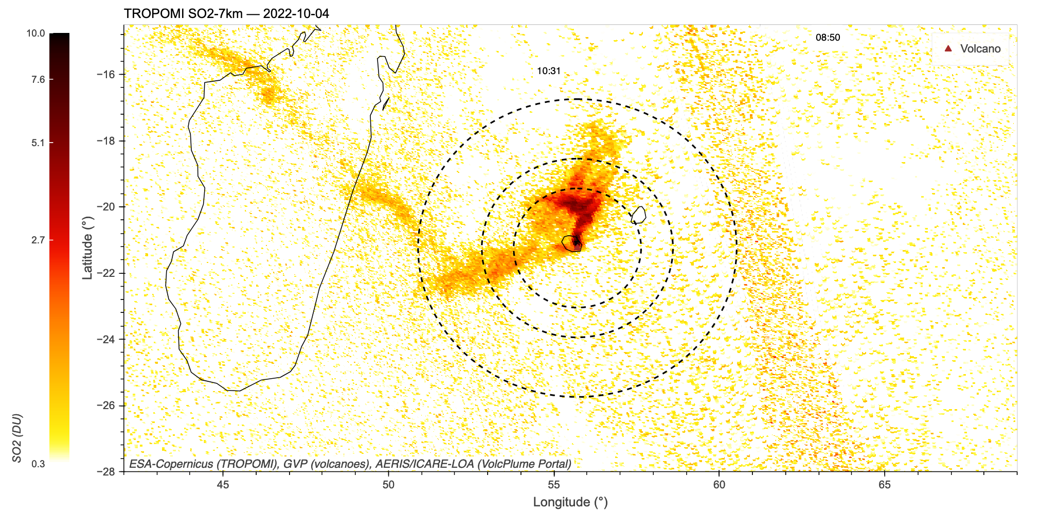
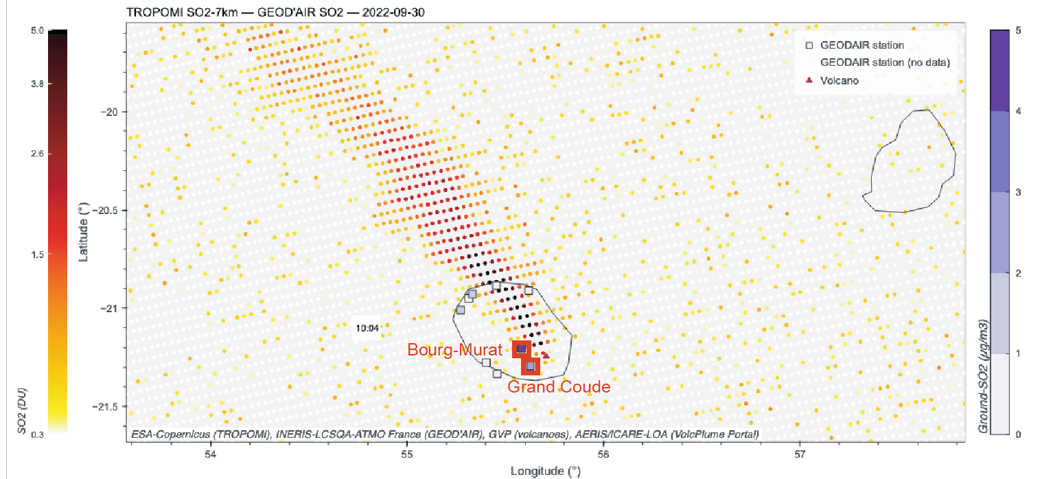
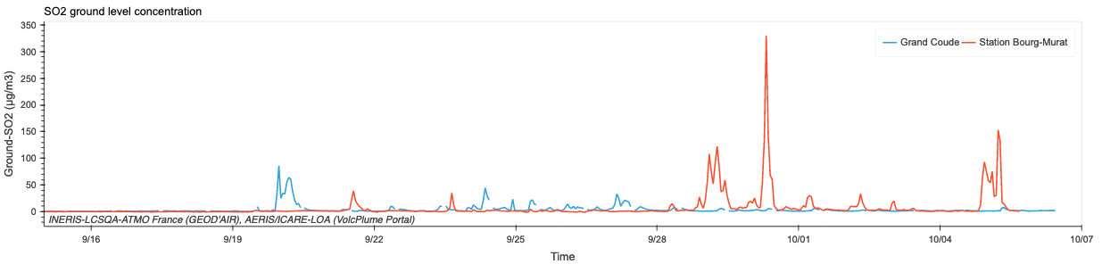
The sulphur-rich off-gas emitted during this eruption may have led to an increase in the SO2 concentration recorded on the ground by the air quality monitoring stations managed by Atmo Réunion, as illustrated in Figure 3 at the Bourg-Murat and Grand-Coude stations. Hourly values of more than 300 g/m3 were thus recorded on 30 September 2022.

Figure 2A : Dispersion map of the SO2 plume from Piton de La Fournaise on 30 September 2022, based on Sentinel-5P/TROPOMI satellite observations, and on SO2 ground concentration measurements at air quality monitoring stations managed by Atmo Réunion. The colour of the station symbol indicates the daily average SO2 concentration.
Figure 2B: Multi-station analysis of the temporal evolution in September-October 2022 of the SO2 ground concentration recorded at Bourg-Murat and Grand Coude, air quality monitoring stations managed by Atmo Réunion (visualisation using the AERIS-ICARE/LOA VolcPlume platform).

Read more :

Plus d'actualités

case-studies

POLLUTION DE L’AIR À L’ÉCHELLE FRANÇAISE ASSOCIÉE AUX FEUX EN GIRONDE

En ce mois de juillet 2022 caniculaire, l’Europe est soumise à de fortes températures, facteur à l’origine du déclenchement de multiples incendies de forêt en Espagne, au Portugal, en France, Grèce, etc. Les masses d’air en provenance du sud apportent leurs cortèges de poussières minérales désertiques et transportent les particules carbonées émises par ces incendies. […]

26.03.2024

case-studies

Measuring the size of stratospheric aerosols from volcanic eruptions

Explosive eruptions can inject massive amounts of sulfate aerosols in the stratosphere, that are capable of perturbing atmospheric chemistry and Earth’s climate. However, crucial information about the size of aerosols, a critical parameter in climate models, is generally missing. To address such gap, an interdisciplinary team from LOA (Laboratoire d’Optique Atmosphérique) at the University of […]

21.03.2024

case-studies

Near-real time monitoring from space of precursory degassing & explosive activity at Soufrière St. Vincent (April 2021)

9–13 Apr 2021: Near Real Time monitoring of explosive activity Synergetic analysis of geostationary & infrasound data Related article: – DATA TERRA, Jul. 2021, “Éruption de La Soufrière Saint-Vincent: mobilisation des pôles de données de Data Terra pour épauler les scientifiques“,https://www.data-terra.org/actualite/eruption-de-la-soufriere-saint-vincent-mobilisation-des-poles-de-donnees-data-terra/ References: Boichu, M. & Grandin, R. (2021). La télédétection épaule la surveillance de l’éruption […]

06.10.2022

Rechercher