Latest status update
Information regarding POLDER/PARASOL reprocessing and synergy with observations from other sensors may be found in the News and events section:
- Release of PARASOL-MODIS unique synergy products – April 2016
- All PARASOL data records now available in HDF format – March 2016
- Full reprocessing of PARASOL data archive with new data sets available – September 2015, update September 2016
- PARASOL Level-1 and Level-2-and-up Data Reprocessing Completion – June 2015
Level-1 products (Satellite measurements)
Level-0 to Level-1 POLDER/PARASOL processing is performed by CNES. This so-called « Level-1 processing » includes calibration, radiometric and geometric processing. CNES completed the final Level-1 reprocessing in 2014, using an improved algorithm incorporating all final in-flight radio/metric calibration parameters (CNES document PARASOL_L1_final_reprocessing.pdf ).
The Level-1 products consist of normalized top-of-the-atmosphere radiance for each channel along with geolocation, time of acquisition, and other relevant parameters and flags. All parameters are given at a spatial resolution close to 6 km x 6 km at nadir and are given on a pixel basis in binary format for each orbit (14 or 15 a day).
CNES issued a document about POLDER and PARASOL level-1 product data format and user manual (POLDER_Level-1_format.pdf , PARASOL_Level-1_format.pdf).
A subset of the PARASOL Level-1 radiances colocated with CALIPSO/CALIOP is available in the CALIOP CALTRACK product suite. The CALTRACK products subset the original products from many sensors at the CALIOP subtrack i.e. they provide all available data temporally and spatially colocated with the LIDAR measurements.
POLDER/PARASOL Level-1 products
| Retrieved parameter | Product Name | Format | Spatial Resolution | Temporal Coverage | Time period |
|---|---|---|---|---|---|
| Level-1 POLDER/PARASOL normalized radiances (directional) | Resp.: CNES | ||||
| Normalized radiance Second component of Stokes Vector (Q) Third component of Stokes Vector (U) | L1_B  | Binary and HDF5 | Full resolution (about 6. km, nadir pixel size) | 1 file/orbit | March 2005 – Oct. 2013 |
| Level-1 PARASOL normalized radiance at CALIPSO/CALIOP subtrack | Resp.: LOA | ||||
| Normalized radiance Second component of Stokes Vector (Q) Third component of Stokes Vector (U) | CALTRACK-333m_ PAR-L1B | HDF5 | 333 m sampling (usually 2 per orbit) | 1 file per CALIOP file | June 2006 – Oct. 2013 |
Level-2 and Level-3 products (Geophysical parameters)
There are two thematic POLDER/PARASOL scientific product suites: « Earth Radiation Budget, Water Vapor and Clouds » and « Aerosols ». They are generated from the Level-1 data alone or in combination with other data sets, using science codes developed by the French science team at LOA.
Products derived from PARASOL data alone include the Level-2 standard data sets (of orbit type), the global Level-3 (monthly and/or decadal), the global Level-3 gridded atmospheric data sets (daily and monthly), and the PARASOL « CALTRACK » products subsets at the CALIPSO/CALIOP subtrack. More recently, an innovative algorithm, called « GRASP » (Generalized Retrieval of Aerosol and Surface Properties), has been developed to retrieve simultaneously many more parameters compared to a standard product.
One unique synergistic Level-2 product is derived using the combination of PARASOL and Aqua/MODIS observations (« PM-L2 »).
- The Level-2 products are derived from individual Level-1 products. All parameters are given at a spatial resolution close to 18.5 kmx18.5 km (1/6 deg. x 1/6 deg., i.e. 3×3 pixels of the Level-1 grid) for each orbit. The parameters are given on a pixel basis in binary format. (POLDER/PARASOL_Level-2_format.pdf )
- The global Level-3 products are generated from the Level-2 products. All parameters are given at 1/6 deg. spatial resolution globally on a pixel basis and in binary format. The aerosol products (land and ocean) include both decadal (i.e. 10-day) and monthly composites and the cloud and radiation products include monthly composites. (POLDER/PARASOL_Level-3_format.pdf)
- The global Level-3 gridded atmospheric products include selected parameters either from the Level-2 data sets (for the daily synthesis) or from the Level-3 (for the monthly synthesis). The selected parameters are reprojected in a Plate-Carrée (i.e. equi-rectangular) projection grid at 1/6 deg. resolution in HDF-EOS format. (POLDER/PARASOL Gridded Atmosphere Product)
- Combination of PARASOL-MODIS data leads to new global Level-2 aerosol and cloud parameters such as the quantization of aerosol plumes over cloud layers or the macro-physical properties and thermodynamic phase of clouds. The parameters are given on an equi-rectangular projection grid at 1/6 deg. spatial resolution in HDF format.
- Subset of PARASOL Level-2 aerosol and cloud parameters at CALIOP subtrack at 5-km spatial resolution (CALTRACK).
- A new algorithm leads to new global daily and monthly Level-3 aerosol products at 1/18 deg. x 1/18 deg. spatial resolution (GRASP).
The tables provide the list of the scientific product parameters and links to the product documentation and illustration (for Level-3).
POLDER/PARASOL Level-2 science products
| Retrieved parameter | Product Name | Format | Spatial Resolution | Temporal Coverage | Time period |
|---|---|---|---|---|---|
| Level-2 Aerosol over ocean | Resp.: LOA | ||||
| Aerosol optical thickness (AOT) Uncertainty of AOT Angstrom exponent Effective radius backscattering coefficient Non-sphericity index | OC2 | Binary and HDF5 | 1/6 deg | 1 file/orbit | March 2005 – Oct. 2013 |
| Level-2 Aerosol over land | Resp.: LOA | ||||
| Aerosol optical thickness Angstrom exponent Aerosol altitude | LS2 | Binary and HDF5 | 1/6 deg | 1 file/orbit | March 2005 – Oct. 2013 |
| Level-2 Earth radiative budget, Water vapor and clouds | Resp.: LOA | ||||
| Shortwave broadband albedo Visible narrowband albedo Cloud fraction Cloud albedo Cloud thermodynamic phase Cloud optical thickness Cloud oxygen pressure Cloud Rayleigh pressure Cloud top oxygen pressure Cloud middle oxygen pressure Cloud geometrical extent Water vapor integrated content | RB2 | Binary and HDF5 | 1/6 deg | 1 file/orbit | March 2005 – Oct. 2013 |
| Level-2 Aerosol and cloud products from combined PARASOL-MODIS | Resp.: LOA | ||||
| Cloud classification Cloud thermodynamic phase Cloud top pressure Cloud geometrical thickness Aerosol optical thickness above cloud layers | PM-L2 | Binary and HDF5 | Clouds: Full resolution Aerosols: 1/6 deg | 1 file/orbit | March 2005 – Oct. 2013 Restricted access |
| Level-2 PARASOL aerosol and cloud parameters at CALIPSO/CALIOP subtrack | Resp.: LOA | ||||
| Aerosol parameters over ocean Aerosol parameters over land Radiative budget, water vapor and clouds parameters Cloud, aerosol above cloud layers | CALTRACK-5km_ PAR-OC2 CALTRACK-5km_ PAR-LS2 CALTRACK-5km_ PAR-RB2 CALTRACK-5km_ PM-L2 | HDF5 | 5 km sampling | 1 file per CALIOP file | June 2006 – Oct. 2013 CALTRACK PM-L2 in restricted access |
POLDER/PARASOL Level-3 science products
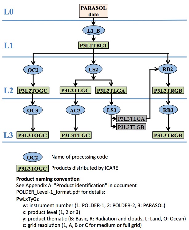
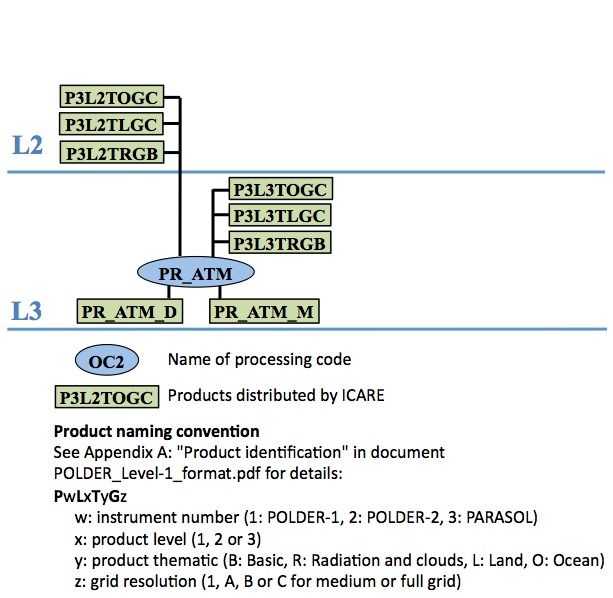
POLDER/PARASOL processing scheme
These diagrams show the POLDER/PARASOL processing and data flow from Level-0 through Level-3 for Aerosol products over ocean (OC2 and OC3) and over land (LS2 and AC3), Land surface products (LS3), radiative budget, water vapor and cloud products (RB2 and RB3) (left diagram), and global gridded atmosphere products (PR_ATM) (right diagram). Click on the image for a larger view. Details on products are provided in Tables below.
Links to the detailed description of the aerosol algorithm and RB, WV and cloud algorithm
![]()