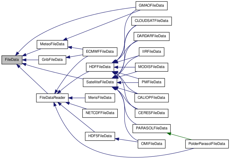
#include <filedata.h>
Public Member Functions | |
| FileData (const string &name="", const string &mode="r") | |
| Build a generic file reader interface. | |
| FileData (const FileData &fd) | |
| Copy constructor. | |
| FileData & | operator= (const FileData &fd) |
| Affectation operator. | |
| virtual | ~FileData () |
| Destructor. | |
| const string | get_name () const |
| file name accessor | |
| virtual string | get_filename () |
| alias to get_name method, dfor data2grid/mapsoperator compatibility | |
| const Date | get_date () const |
| return the date of data' acquisition start | |
| const bool | contain_time (const double time=-1.) const |
| test if the file contains data that occur at time If time is -1 (deault), always return true | |
| virtual void * | read_data (void *data, const char *sds_name, int *start=NULL, int *stride=NULL, int *edges=NULL, int rank=-1)=0 |
| Read the selected data in the file. | |
| double | get_time_coverage () const |
| virtual void | close_data_file () |
| closes the file | |
| virtual void | open_data_file () |
| open the file | |
| virtual const bool | contain_location (const float &lat, const float &lon, const double &tolerance) |
| check if this file has eventually data coincident with (lat,lon) | |
| virtual const bool | contain_data (const float &lat, const float &lon, const double &time, const double &colocation_tolerance) |
| check if the file has possible (lat,lon) coincidence | |
| virtual void | load_geolocation_data () |
| read the geolocations data and put it in memory | |
| virtual void | free_geolocation_data () |
| free eventually loaded geolocation data | |
| virtual const bool | is_geolocation_data_loaded () const |
| check if the geolocation data have been already loaded | |
| virtual void | get_dataset_fill_value (const string &ds_name, void *fillvalue) |
| read the given dataset's fill value TODO Same method with many names of this method transfered from filedatareader. Need to be reformatted after functionnal tests with Data2Grid/MapsOperator | |
| virtual vector< int > | get_dataset_dimension (const string &sds_name) |
| return the given dataset size along each axis | |
| template<class X > | |
| void | get_fillValue (const string &ds_name, X &fillValue) |
| read the given dataset's fill value | |
| virtual void | get_fillValue (const string &ds_name, void *fillValue) |
| template<class X > | |
| void | get_fill_value (const string &ds_name, X &fillValue) |
| virtual void | get_fill_value (const string &ds_name, void *fillValue) |
| virtual bool | is_viewing_directions_data_loaded () |
| test if the data requested for computing the viewing directions has been loaded | |
| virtual void | load_viewing_directions_data () |
| load the data requested for computing the viewing directions | |
| virtual void | free_viewing_directions_data () |
| free the data requested for computing the viewing directions | |
| virtual void | get_viewing_directions (const vector< int > &ipix, vector< Observation > &v_obs) |
| constucts the viewing directions observations for the given pixel | |
Static Public Member Functions | |
| static void | check_geolocation (const float lat, const float lon) |
| check the validity of the (lat, lon) coordinates. If lat not in [-90, 90] or lon not in [-180, 180], raise an exception | |
Protected Member Functions | |
| void | set_name (const string &name) |
| void | set_date (const Date &d) |
Protected Attributes | |
| string | name |
| string | mode |
| Date * | date |
| double | time_coverage |
Detailed Description
Generic class managing the reading. It describes the data generally
Constructor & Destructor Documentation
| FileData::FileData | ( | const string & | name = "", |
|
| const string & | mode = "r" | |||
| ) |
Build a generic file reader interface.
- Exceptions:
-
bad_file if the name given in parametre doesn't exist or is NULL
bad_file_opening_mode :
- if the opening mode isn't allowed. At this time, only "r" is allowed.
- if the user isn't authorized to access to this file.
- if the opening mode isn't allowed. At this time, only "r" is allowed.
- Parameters:
-
name the name of the file (path included) we want to parse / mode the file's opening mode for this file. At this time, only "r" is allowed
References date.
| FileData::FileData | ( | const FileData & | fd | ) |
Member Function Documentation
| void FileData::check_geolocation | ( | const float | lat, | |
| const float | lon | |||
| ) | [static] |
check the validity of the (lat, lon) coordinates. If lat not in [-90, 90] or lon not in [-180, 180], raise an exception
- Parameters:
-
lat latitude lon longitude
Referenced by PARASOLFileData::geolocation_to_grid().
| virtual void FileData::close_data_file | ( | ) | [inline, virtual] |
closes the file
- Warning:
- here for interface implementation prupose. All subclasses should implement this method
Reimplemented in CALIOPFileData, CERESFileData, CLOUDSATFileData, DARDARFileData, ECMWFFileData, GribFileData, HDF5FileData, HDFFileData, IIRFileData, MerisFileData, MODISFileData, NETCDFFileData, OMIFileData, PARASOLFileData, PMFileData, PolderParasolFileData, and SatelliteFileData.
| virtual const bool FileData::contain_data | ( | const float & | lat, | |
| const float & | lon, | |||
| const double & | time, | |||
| const double & | colocation_tolerance | |||
| ) | [inline, virtual] |
check if the file has possible (lat,lon) coincidence
- Warning:
- it's an EVENTUAL coincidence. That is not a proof !!!
- here for interface implementation prupose. All subclasses should implement this method
- Parameters:
-
lat latitude lon longitude time time colocation_tolerance the acceptable bias (in km or degrees. Supposed to be in, a plane approximation) between [lat,lon] and the nearest data point.
- Returns:
- true if can eventually contain a coincidence with the point.
- Warning:
- at this time always true. I don't have a good way to do it
Reimplemented in CALIOPFileData, CERESFileData, CLOUDSATFileData, DARDARFileData, IIRFileData, MODISFileData, OMIFileData, PARASOLFileData, PMFileData, and SatelliteFileData.
| virtual const bool FileData::contain_location | ( | const float & | lat, | |
| const float & | lon, | |||
| const double & | tolerance | |||
| ) | [inline, virtual] |
check if this file has eventually data coincident with (lat,lon)
- Warning:
- here for interface implementation prupose. All subclasses should implement this method
- Parameters:
-
lat the latitude of the event lon the longitude of the event tolerance acceptable bias between the nearest point in the data and the given (lat,lon) point
- Returns:
- true if a point in the data has been found in the colocation frame
Reimplemented in CALIOPFileData, CERESFileData, CLOUDSATFileData, DARDARFileData, IIRFileData, MODISFileData, OMIFileData, PARASOLFileData, PMFileData, and SatelliteFileData.
| const bool FileData::contain_time | ( | const double | time = -1. |
) | const |
test if the file contains data that occur at time If time is -1 (deault), always return true
- Parameters:
-
time a measure time using TAI93 convention (number of seconds since 1993/01/01 at 00:00:00)
- Returns:
- true if the file has data time stamped with time
References date, Date::get_TAI93_time(), and time_coverage.
Referenced by PMFileData::contain_data(), PARASOLFileData::contain_data(), OMIFileData::contain_data(), MODISFileData::contain_data(), IIRFileData::contain_data(), DARDARFileData::contain_data(), CLOUDSATFileData::contain_data(), CERESFileData::contain_data(), CALIOPFileData::contain_data(), and CERESFileData::get_index().
| virtual void FileData::free_geolocation_data | ( | ) | [inline, virtual] |
free eventually loaded geolocation data
- Warning:
- here for interface implementation prupose. All subclasses should implement this method
Reimplemented in CALIOPFileData, CERESFileData, CLOUDSATFileData, DARDARFileData, ECMWFFileData, IIRFileData, MODISFileData, PARASOLFileData, PMFileData, and SatelliteFileData.
| virtual vector<int> FileData::get_dataset_dimension | ( | const string & | sds_name | ) | [inline, virtual] |
return the given dataset size along each axis
- Parameters:
-
ds_name [IN] dataset name
- Returns:
- the axis dimensions in ordering [..., Z, Y, X]
Reimplemented in GribFileData, HDF5FileData, HDFFileData, MerisFileData, NETCDFFileData, and PolderParasolFileData.
| virtual void FileData::get_dataset_fill_value | ( | const string & | ds_name, | |
| void * | fillvalue | |||
| ) | [inline, virtual] |
read the given dataset's fill value TODO Same method with many names of this method transfered from filedatareader. Need to be reformatted after functionnal tests with Data2Grid/MapsOperator
- Parameters:
-
ds_name [IN] dataset name fillvalue [OUT] fill value.
Reimplemented in GribFileData, HDF5FileData, HDFFileData, MerisFileData, NETCDFFileData, and PolderParasolFileData.
| const Date FileData::get_date | ( | ) | const [inline] |
return the date of data' acquisition start
- Returns:
- the acquisition date
References date.
Referenced by IIRFileData::contains_data_at().
| virtual string FileData::get_filename | ( | ) | [inline, virtual] |
alias to get_name method, dfor data2grid/mapsoperator compatibility
- Returns:
Reimplemented in MerisFileData.
References get_name().
| void FileData::get_fillValue | ( | const string & | ds_name, | |
| X & | fillValue | |||
| ) | [inline] |
read the given dataset's fill value
- Parameters:
-
ds_name [IN] dataset name fillvalue [OUT] fill value.
| const string FileData::get_name | ( | ) | const [inline] |
file name accessor
- Returns:
- the name with its full path
References name.
Referenced by get_filename(), MODISFileData::init(), CERESFileData::init(), CALIOPFileData::is_same_orbit(), and HDFFileData::load_hdf_file().
| virtual void FileData::get_viewing_directions | ( | const vector< int > & | ipix, | |
| vector< Observation > & | v_obs | |||
| ) | [inline, virtual] |
constucts the viewing directions observations for the given pixel
- Parameters:
-
ipix pixel indice(s) v_obs vector of observation(s) for the given pixel
Reimplemented in CALIOPFileData, PARASOLFileData, and SatelliteFileData.
| virtual const bool FileData::is_geolocation_data_loaded | ( | ) | const [inline, virtual] |
check if the geolocation data have been already loaded
- Warning:
- here for interface implementation prupose. All subclasses should implement this method
Reimplemented in CALIOPFileData, CERESFileData, IIRFileData, MODISFileData, PARASOLFileData, PMFileData, and SatelliteFileData.
| virtual void FileData::load_geolocation_data | ( | ) | [inline, virtual] |
read the geolocations data and put it in memory
- Warning:
- here for interface implementation prupose. All subclasses should implement this method This method is used to make the search of the indexes of a (lat,lon,time) point faster.
Reimplemented in CALIOPFileData, CERESFileData, CLOUDSATFileData, DARDARFileData, IIRFileData, MODISFileData, OMIFileData, PARASOLFileData, PMFileData, and SatelliteFileData.
| virtual void FileData::open_data_file | ( | ) | [inline, virtual] |
open the file
- Warning:
- here for interface implementation prupose. All subclasses should implement this method
Reimplemented in CALIOPFileData, CERESFileData, CLOUDSATFileData, DARDARFileData, ECMWFFileData, GribFileData, HDF5FileData, HDFFileData, IIRFileData, MerisFileData, MODISFileData, NETCDFFileData, OMIFileData, PARASOLFileData, PMFileData, PolderParasolFileData, and SatelliteFileData.
| virtual void* FileData::read_data | ( | void * | data, | |
| const char * | sds_name, | |||
| int * | start = NULL, |
|||
| int * | stride = NULL, |
|||
| int * | edges = NULL, |
|||
| int | rank = -1 | |||
| ) | [pure virtual] |
Read the selected data in the file.
- Warning:
- If you delegate the allocation of the buffer at this method, you need to call delete[] data yourself.
- Parameters:
-
data the buffer to fill with the read values. Can be NULL. In this case, the allocation is done by the method sds_name the name of the sds (Scientific Data Set) we want to access. start begining of the selection. If NULL, start at (0,0) if rank is 2 ; (0,0,0) if rank is 3... stride step between 2 interesting values. If NULL, this step is set to 1 in each dimension (ie all values will be read) edges number of values to be read in each dimension. if NULL, it will be all data along each dimension. rank the dimension of start, stride and edges
- Returns:
- a pointer to the read data array. It is useful when you let this method manage the allocation to update the allocated pointer to the data. If you've done it yourself or you are using a static buffer, it isn't necessary to catch this return pointer
Implemented in ECMWFFileData, GribFileData, HDF5FileData, HDFFileData, MerisFileData, NETCDFFileData, PARASOLFileData, and PolderParasolFileData.
Referenced by GMAOFileData::load_height_level(), and GMAOFileData::load_time_level().
| void FileData::set_date | ( | const Date & | d | ) | [inline, protected] |
| void FileData::set_name | ( | const string & | name | ) | [inline, protected] |
set the name of the file
- Parameters:
-
_name the new name
Member Data Documentation
Date* FileData::date [protected] |
the date when the data have been acquired
Referenced by contain_time(), FileData(), get_date(), MODISFileData::get_radix(), MeteoFileData::get_time_index(), MeteoFileData::get_time_max(), MeteoFileData::get_time_min(), DARDARFileData::load_geolocation_data(), operator=(), MODISFileData::parse_filename(), GMAOFileData::parse_filename(), ECMWFFileData::parse_filename(), set_date(), and ~FileData().
string FileData::mode [protected] |
the opening mode : only "r" supported at this time
Referenced by FileData(), GribFileData::open_data_file(), and operator=().
string FileData::name [protected] |
the name of the file (with its path)
Reimplemented in HDF5FileData.
Referenced by FileData(), NETCDFFileData::get_dataset_dimension(), get_name(), GribFileData::open_data_file(), operator=(), GribFileData::print_keys(), and NETCDFFileData::read_data().
double FileData::time_coverage [protected] |
the duration of the acquisition
Referenced by contain_time(), ECMWFFileData::ECMWFFileData(), MeteoFileData::get_time_index(), MeteoFileData::get_time_max(), CERESFileData::init(), MeteoFileData::MeteoFileData(), ECMWFFileData::parse_filename(), and MODISFileData::set_time_coverage().
The documentation for this class was generated from the following files:
- /home/pascal/depot/filedata/src/filedata.h
- /home/pascal/depot/filedata/src/filedata.cpp