This page provides a summary documentation of the SEVIRI and CALIOP aerosol products available at ICARE, focusing on ICARE’s specific developments in the framework of MACC. It also aims at providing access to data and browse imagery to MACC partners.
MACC is the precursor project for the Copernicus Atmosphere Monitoring Service CAMS. ICARE’s contribution to MACC is to provide current operational aerosol products over ocean and land:- Near Real Time SEVIRI aerosol over ocean (since MACC’s inception)
- SEVIRI aerosol over land (MACC-II)
- Near Real Time CALIOP aerosol products (MACC-II) .
The following tables list the aerosol products processed by ICARE and made available to MACC partners. The tables provide links to the product description and algorithm description (if available).
| SEVIRI and CALIOP Level-2 aerosol products | ||||||
|---|---|---|---|---|---|---|
| Retrieved parameter | Product Name | Sensor | Spatial Resolution | Temporal Resolution | Release to MACC partners | Public Release |
| Level-2 Near Real Time SEVIRI aerosol over ocean | Resp.: IPSL/LSCE | |||||
| Aerosol Optical Thickness (550 nm) Angstrom Exponent |
SEV_AER-OC | SEVIRI | Native (3 km at nadir) |
15-min and Daily Mean |
Since beginning of project |
2005 |
| Level-2 SEVIRI aerosol over land | Resp.: HYGEOS | |||||
| AOT (550 nm) Angstrom Exponent |
SMAOL | SEVIRI | Native (3 km at nadir) |
15-min | April 2012 | TBD |
| Level-2 CALIOP aerosol | Resp.: NASA/LaRC/ASDC | |||||
| Aerosol extinction profile Aerosol classification |
05kmAPro 05kmALay |
CALIOP | Native (5km-average) |
1 overpass/day (at most) | Nov. 2011 | 2006 |
SEVIRI Aerosol over ocean
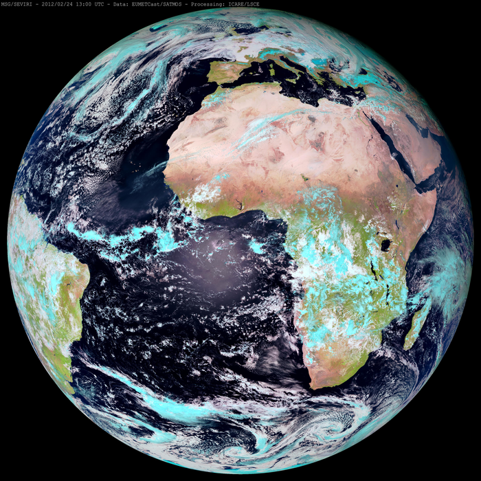
Data Sources and product availabilitySEVIRI data are routinely acquired at ICARE since May 2005. ICARE currently acquires SEVIRI Level-1B data from SATMOS/CMS in near-real time and processes them within hours of acquisition to generate the Level-2 aerosol products.
The Level-1 data are processed on a daily basis to generate the Level-2 aerosol products over oceans: “Aerosol Optical Depth and Angstrom Exponent over Ocean”. The Level-1B Calibrated Radiances data are in restricted access while Level-2 products and browse imagery are made available to the public from the ICARE web site (Archive and NRT). Current status of the data and product availability can be seen in the ICARE catalogue. The catalogue is automatically updated as new data are received and as new products are generated. The aerosol products are generally available within 24 hours of sensing.
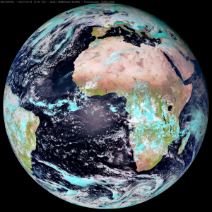
Imagery over the whole SEVIRI archive (2004 to present) is available through the ICARE multi-sensor web interface for comparison to other observation data sets (satellite sensor retrievals, AERONET data) or to the MACC aerosol forecast to facilitate observation/model comparisons.
Algorithm descriptionMSG is a joint project between ESA and EUMETSAT to provide meteorological observations from geostationary orbit. SEVIRI (Spinning Enhanced Visible and Infra-red Imager) is the main instrument onboard MSG-1 and MSG-2 (Meteosat Second Generation) at 0 degree latitude. The “SEVIRI aerosol over ocean” algorithm implemented at ICARE was initially developed by IPSL/LSCE (Thieuleux et al., 2005 [1]) under a CNES grant. The objective was to develop an algorithm able to distinguish between different aerosol types, and derive the AO
D (Aerosol Optical Depth) and AE (Angström Exponent) over ocean from the SEVIRI visible and near-infrared channels at 0.6 µm and 0.8 µm, using the spectral signature of aerosol optical thickness. The output products are the aerosol optical thickness at one wavelength (0.81 µm or 0.55 µm) and the Angström Exponent. The Angström Exponent is directly derived from the spectral AOD and provides information on the aerosol size and thus information about the dominant aerosol type. The algorithm takes advantage of the high frequency of observations (one image every 15 minute), and the high spatial resolution (3 km at nadir) of the SEVIRI instrument.
Adaptation to ICARE production system and evaluation of resultsThe code was ported to ICARE in 2005 and streamlined for operational processing, browse production, archive and distribution. The product name is Level-2 SEV_AER-OC. The products generated are the Aerosol Optical Depth at 550 nm and Angstrom Exponent at sensor’s native resolution for each slot (i.e. every 15 minutes); a daily average is also provided.
In the framework of the GEOmon project, ICARE compared the whole archive of SEVIRI AOD products to ground-based measurements. It was part of an evaluation of various aerosol products derived from current operational satellite observations (Bréon et al, 2011 [2]).
Adaptation to MACC requirementsDuring MACC, the initial production mode was consolidated to take advantage of ICARE latest production capabilities, including monitoring tools and automated alert mechanisms, with reinforced product traceability.
The initial format of the output file was flat binary. It was changed to the HDF format (ICARE’s standard format) in order to provide a self-descriptive format. It was also enriched by pixel-wise information regarding surface classification, science flag, and geometry. Products are currently generated and distributed in HDF format for all slots between 04:00 UTC and 19:45 UTC and for the daily average.
A modified SEVIRI aerosol product adapted to MACC requirements was developed. It includes additional parameters (AOD at multiple wavelengths), time and geographical information were added to the standard products and the output format is BUFR to ease ingestion by the MACC global assimilation system. This modified version will eventually include the uncertainty information associated with the aerosol parameters.
Also, to ease comparison between satellite aerosol products and forecast, ICARE implemented a observation/model comparison module in the multi-sensor browse interface (see examples).
SEVIRI Aerosol over land
Data source and product availabilitySEVIRI data are routinely acquired at ICARE since May 2005. ICARE currently acquires SEVIRI Level-1B data from SATMOS/CMS in near-real time and processes them within hours of acquisition to generate the Level-2 aerosol products.
The year 2009 data set was processed with the current version V1.3.2 (still in development) and the data are processed routinely since April 2012. Because the processing scheme uses a 15-day period centered on the product date, there is a latency of 8 days for the product. Products and browse imagery of aerosol over land are currently restricted to MACC partners and available on the web or by FTP upon request.
Algorithm descriptionThe algorithm was initially developed by HYGEOS under a CNES grant to derive aerosol optical depth (AOD) over land from the SEVIRI visible and near-infrared channels. Bernard et al. (2011)[3] describe the algorithm physical background and validation results over Europe for 3 months of data in 2006.
The SEVIRI algorithm uses the calibrated reflectances (Level 1B) in channels 0.63, 0.81 and 1.64 µm as input and derives the AOD at 0.63 µm and the aerosol model over land. The method is based on an estimate of the surface reflectance for each slot. To obtain this estimate, the minimum of the TOA reflectance over a 14-day time series is corrected for atmospheric effects (molecular scattering and gaseous absorption, and a residual aerosol background). Thus, it is assumed that one can get a clear scene image (i.e. cloud free) over this time period and that land properties and sun angles do not change significantly. The AOD at 0.63 µm is then retrieved for 5 aerosol models using radiative transfer calculations to match measurements and simulations. The best aerosol model is determined using the near infrared channels at 0.81 and 1.64 µm.
The code was ported to ICARE in 2009 to be streamlined for operational processing in the ICARE production environment. That includes production of browse imagery and eventually archive and distribution to the public. A whole year of SEVIRI data (2009) was processed for evaluation in 2010.
Adaptation to MACC requirements
In the framework of MACC, routine processing started at the beginning of April 2012, as planned. The current version (V1.3.2, provisional status) is made available to MACC partners upon request. A minor release is planned for early June 2012 to provide AOD at 0.55 µm rather than 0.63 µm. ICARE is currently working with HYGEOS on a new version of the algorithm.
ICARE will adapt the standard product to fit MACC specific requirements including the conversion of the standard HDF format into BUFR format, and the addition of parameters and pixel-wise quality information.
CALIOP data
Data Sources and product availabilityICARE retrieves CALIPSO/CALIOP aerosol products (Level-2 aerosol extinction profile and aerosol classification) from NASA/ASDC on a daily basis. Products are made available to the users from ICARE web and FTP sites since launch in June 2006.
Adaptation to MACC requirements
The standard aerosol products can be modified to fit MACC-II requirements for ingestion by the MACC global assimilation system.
Data Access
- The ICARE Multi-sensor browse interface
- The ICARE Archive (Registration required)
Examples with the multi-sensor browse interface
The screenshot examples below show a dust storm over the Mediterranean Sea in example 1 and off West Africa in example 2 (click to enlarge):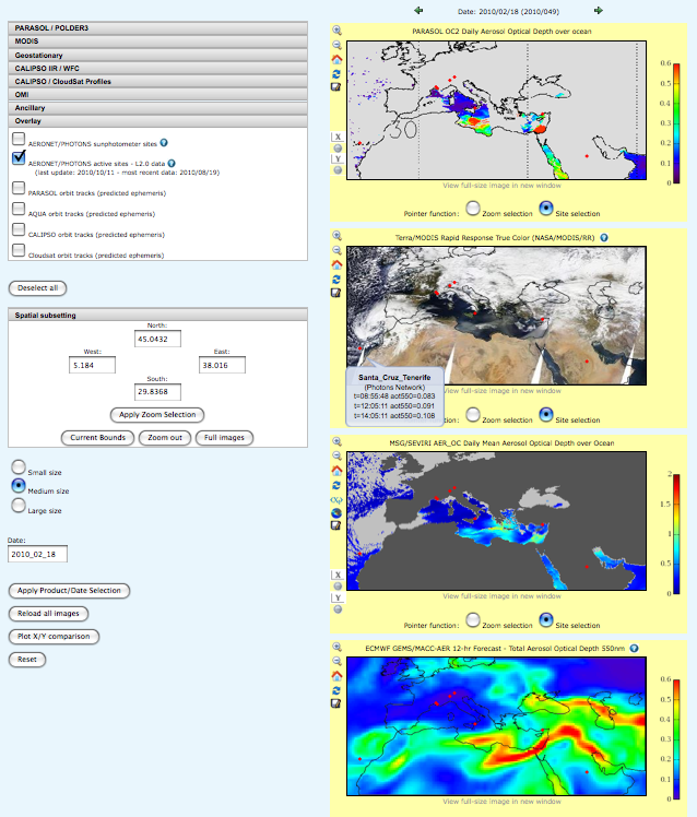
Example 1 (for February 18, 2010) shows coincident data of several sensors and MACC aerosol forecast, with AERONET data overlayed (red dots):
- ECMWF GEMS/MACC-AER 12-hr Forecast – Total Aerosol Optical Depth 550nm
- PARASOL OC2 Daily Aerosol Optical Depth over ocean at 865nm
- Aqua/MODIS Rapid Response True Color (NASA/MODIS/RR)
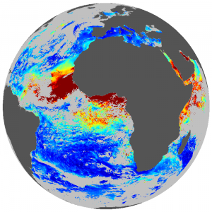
- MSG/SEVIRI AER_OC Daily Mean Aerosol Optical Depth over Ocean
https://www.icare.univ-lille.fr//asd-content/browse?parasol_oc2_taua=true&modis_rr_aqua=true&seviri_aer_oc_d3_tau=true&macc_aod550=true&active_aeronet_sites=true&north=57.25&west=-24.31&east=63.61&south=18.02&date=2010_02_18.
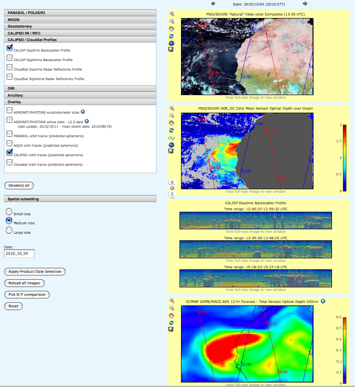
Example 2 (for October 4, 2010) shows coincident data of several sensors and MACC aerosol forecast, with CALIPSO orbit tracks overlayed:
- ECMWF GEMS/MACC-AER 12-hr Forecast – Total Aerosol Optical Depth 550nm
- SEVIRI false color composite
- MSG/SEVIRI AER_OC Daily Mean Aerosol Optical Depth over Ocean
- CALIOP Daytime Backscatter Profiles
References
[1] F. Thieuleux, C. Moulin, F. M. Bréon, F. Maignan, J. Poitou and D. Tanré : Remote Sensing of Aerosols over the oceans using MSG/SEVIRI Imagery, Ann. Geophys., 23, 3561-3568, doi:10.5194/angeo-23-3561-2005[2] Bréon, FM, A. Vermeulen, J. Descloitres: An evaluation of satellite aerosol products against sunphotometer measurements. Remote Sensing of Environment (2011), doi:10.1016/j.rse.2011.06.017
[3] E. Bernard, C. Moulin, D. Ramon, D. Jolivet, J. Riedi, and J.-M. Nicolas: Description and validation of an AOT product over land at the 0.6 µm channel of the SEVIRI sensor onboard MSG. Atmos. Meas. Tech., 4, 2543-2565, 2011