This page provides a summary documentation of the AERUS-GEO (Aerosol and surface albEdo Retrieval Using a directional Splitting method – application to GEOstationary data) products available at ICARE and how to access the data.
ICARE routinely acquires SEVIRI Level-1B data from SATMOS/CMS in near-real time. ICARE is in charge of the data processing to generate the daily aerosol products using the AERUS-GEO science code provided by the French CNRM laboratory, and streamlined to run in the ICARE production environment.
ICARE is also in charge of the archiving and distribution of these science products to the user community through the online archive, SFTP, or SSH (see the Data Access section below for data availability and access procedures).
In addition, ICARE provides browse images associated with the generated products. Imagery over the whole SEVIRI archive (2005 to present) is available through ICARE’s multi-sensor web interface and geostationary browse interface, for comparison to many other data sets (satellite sensor retrievals, AERONET data), including the GEMS/MACC aerosol forecast, to facilitate observation/model comparisons.
Summary
Aerosols play a key role in the study of climate, weather forecast, air quality, civil aviation, and other important topics. These atmospheric particles are related to a rapid temporal variation and they are heterogeneously distributed over the surface of the Earth. In this context spaceborne remote sensing represents a unique tool to detect, characterize and monitor aerosols at the regional and global scales.
The AERUS-GEO approach developed by the CNRM laboratory (Centre National de Recherches Météorologiques; Univ. de Toulouse, Météo France, CNRS) efficiently processes observations from the SEVIRI camera aboard the geostationary satellite Meteosat Second Generation (MSG) operated by EUMETSAT for the estimation of aerosol and surface properties [1][2]. The retrieval strategy separates the contributions related to the aerosols and the surface thanks to the directional and temporal inspection of the satellite signal, which is modeled using a kernel based model. A simplified Kalman filter approach is used for the mathematical inversion of this model and for the propagation in time of the retrieved information and the associated uncertainties.
The outputs of the AERUS-GEO approach include a daily-averaged Aerosol Optical Thickness (AOD) at 0.635 micrometers, the Angström exponent between 0.635 and 1.64 micrometers, and the associated uncertainties and quality flag. All variables are disseminated in the native SEVIRI geostationary grid. Figure 1 shows the RGB image at noon and spatial distribution of the daily AOD at 0.635 μm for March 30th, 2010 (click to enlarge).
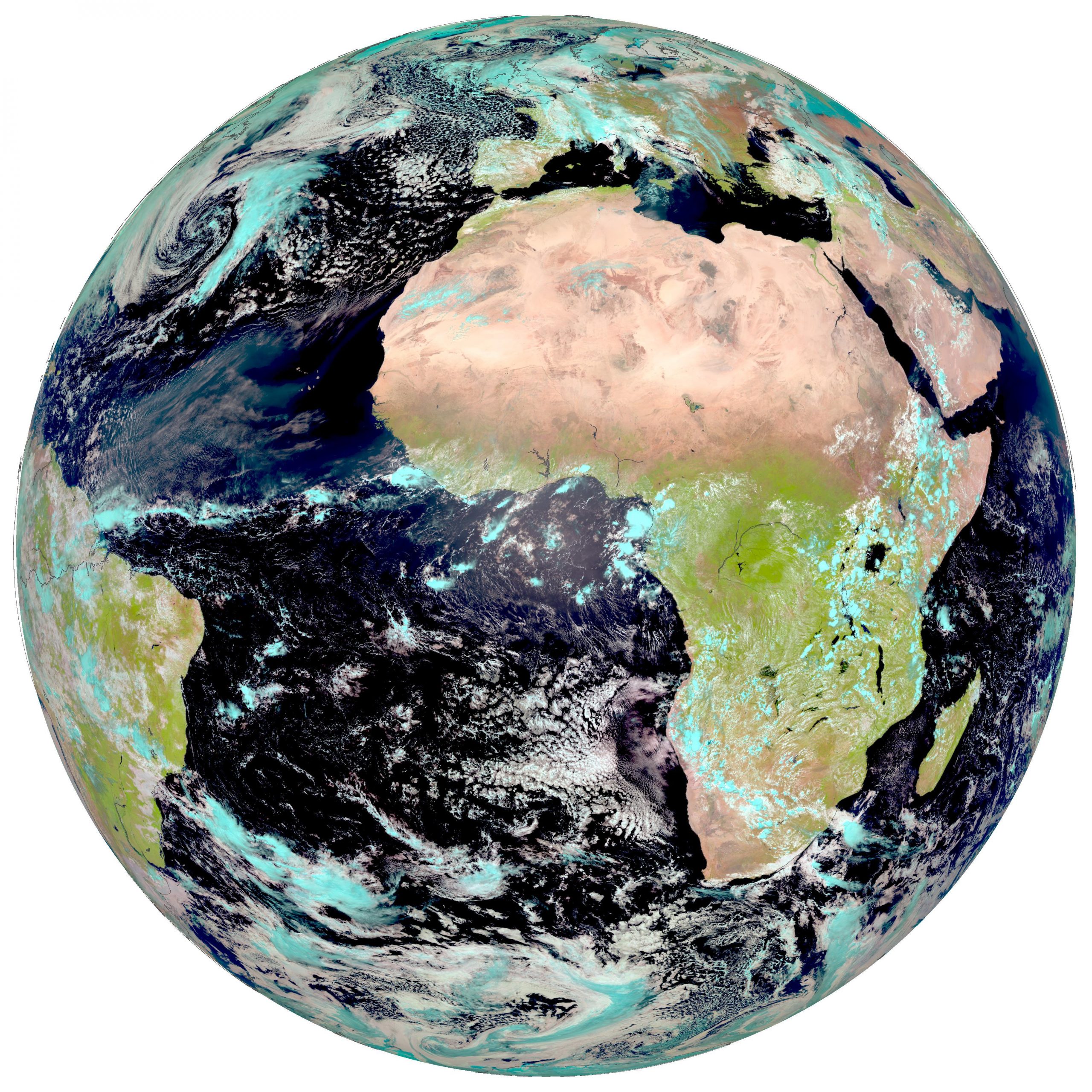
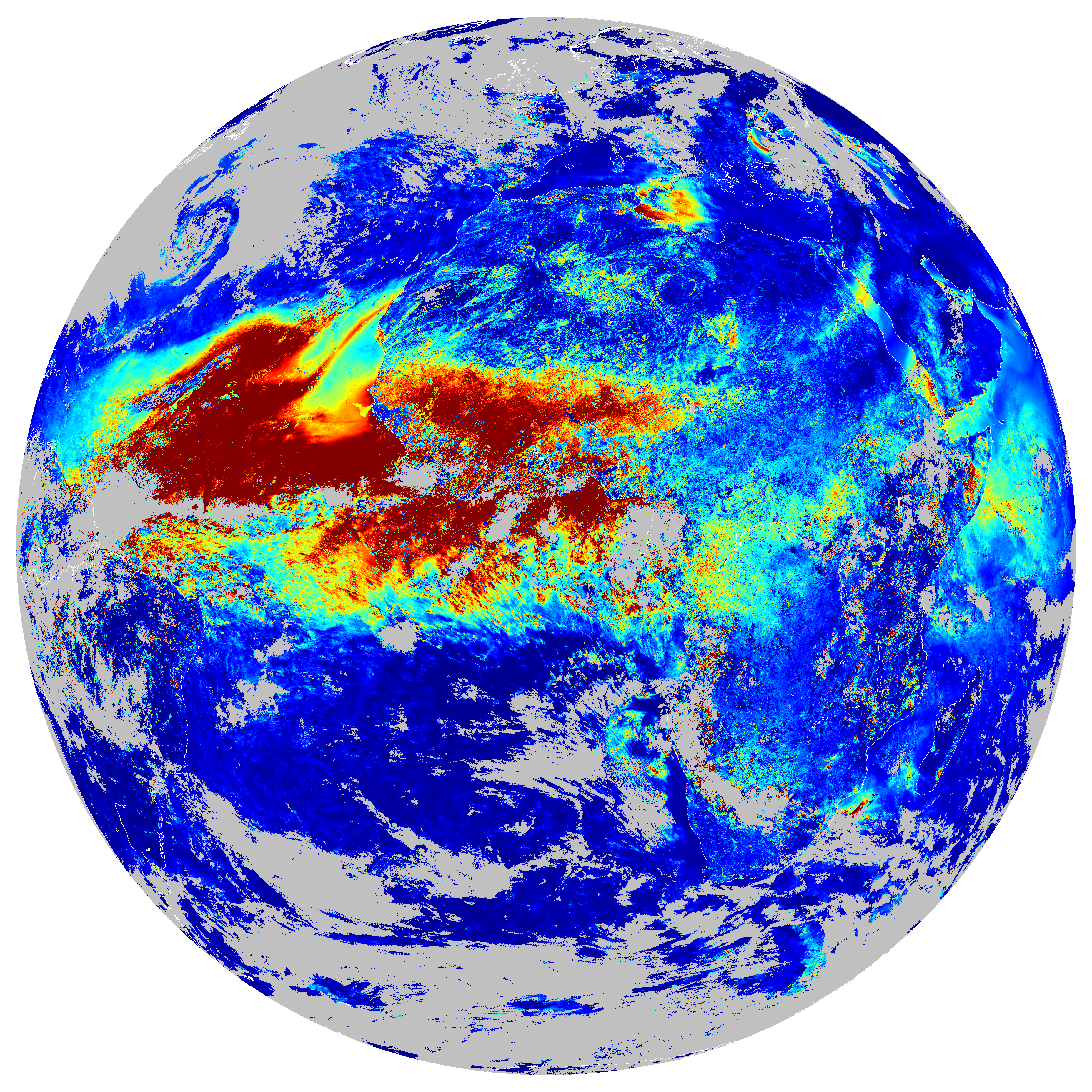
Figure 1: For March 30th, 2010, (left) SEVIRI RGB composite at noon and (right) daily AOD at 0.635 μm retrieved by AERUS-GEO
A comparison of the daily AOD values retrieved by AERUS-GEO against the concomitant ground measurements acquired by the AERONET stations within the MSG disk is shown in Figure 2. It can be seen that the retrieved AOD values for the period between 2006 to 2010 are unbiased and well correlated with respect to AERONET data. Other studies underlined the notable accuracy of AOD retrieved by AERUS-GEO when compared to ground measurements and other satellite aerosol products [3].
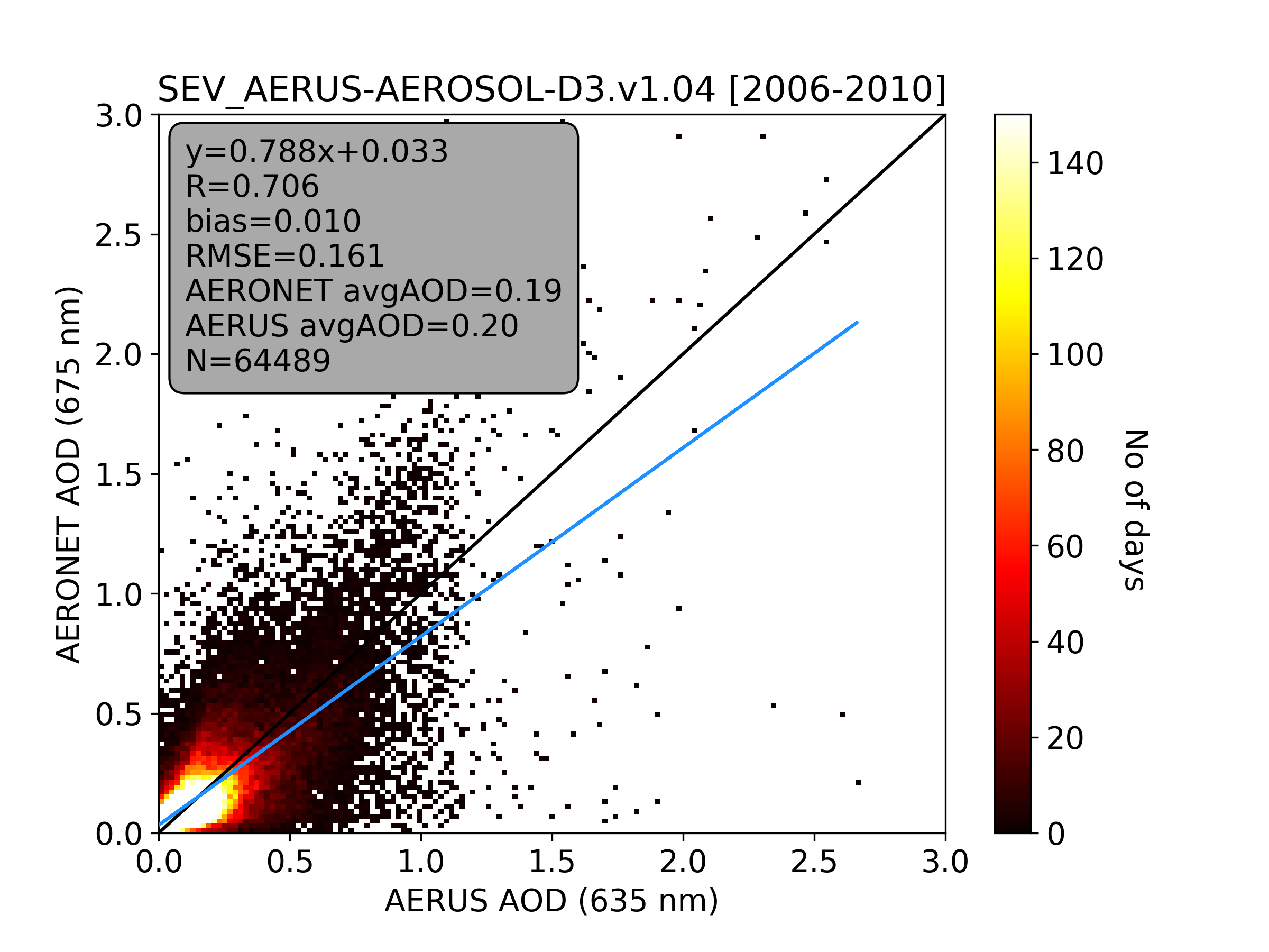
Figure 2: Comparison between AERUS-GEO derived AOD at 0.635 μm with respect to concomitant AERONET measurements
Data Access
Access to the data is subject to the Data Policy below. All users must register beforehand. Registered users can access the data through the Archive Web Interface and the SFTP server. ICARE provides a web interface dedicated to geostationary products to visualize AERUS-GEO browse images.
ICARE archive and SFTP access
Two types of daily aerosol products derived by AERUS-GEO are available:
- A near real time product using forecasts from the ECMWF as input data:
https://www.icare.univ-lille.fr/asd-content/archive/?dir=GEO/MSG+0000/SEV_AERUS-AEROSOL-NRT-D3.v1.01
sftp://sftp.icare.univ-lille.fr/SPACEBORNE/GEO/MSG+0000/SEV_AERUS-AEROSOL-NRT-D3.v1.01
(or using SFTP from a terminal: sftp sftp.icare.univ-lille.fr)
- A reanalysed data record from 2005 until today using ECMWF reanalysis:
Version 1.04 :
https://www.icare.univ-lille.fr/asd-content/archive/?dir=GEO/MSG+0000/SEV_AERUS-AEROSOL-D3.v1.04
sftp://sftp.icare.univ-lille.fr/SPACEBORNE/GEO/MSG+0000/SEV_AERUS-AEROSOL-D3.v1.04
Geostationary browse interface
Quicklooks of AERUS-GEO products (along with other products and color composites) can be visualized on the ICARE web interface dedicated to geostationary products: Geoview
- MSG/SEVIRI AERUS-GEO 0.63µm Daily (daytime) Aerosol Optical Depth
- MSG/SEVIRI AERUS-GEO Daily (daytime) Angstrom Exponent
Current work
CNRM and AERIS/ICARE are currently working together to provide retrievals of aerosol properties at the sub-daily scale, This work is justified by the diurnal variations of the aerosol load, which may show a 30% departure with regard to the daily averaged AOD. The unique potential of geostationary satellites allows them to provide accurate information on the temporal evolution of aerosols during the day [4], which constitute a need of the climate and weather communities. This is done thanks to the newly developed i-AERUS-GEO algorithm, which estimates the AOD every 15 minutes (i.e. the temporal resolution of SEVIRI) based on the robust inversion of an efficient radiative transfer model [5]. This “instantaneous” version of AERUS-GEO runs in parallel to a daily version of it that estimates the surface BRDF from the SEVIRI observations accumulated during the day. Figure 3 shows some results of the on-going validation showing the match between the 15-min AOD retrievals estimated by i-AERUS-GEO and the concomitant AERONET measurements corresponding to four ground stations. The added value of the instantaneous retrievals against daily ones is also highlighted.
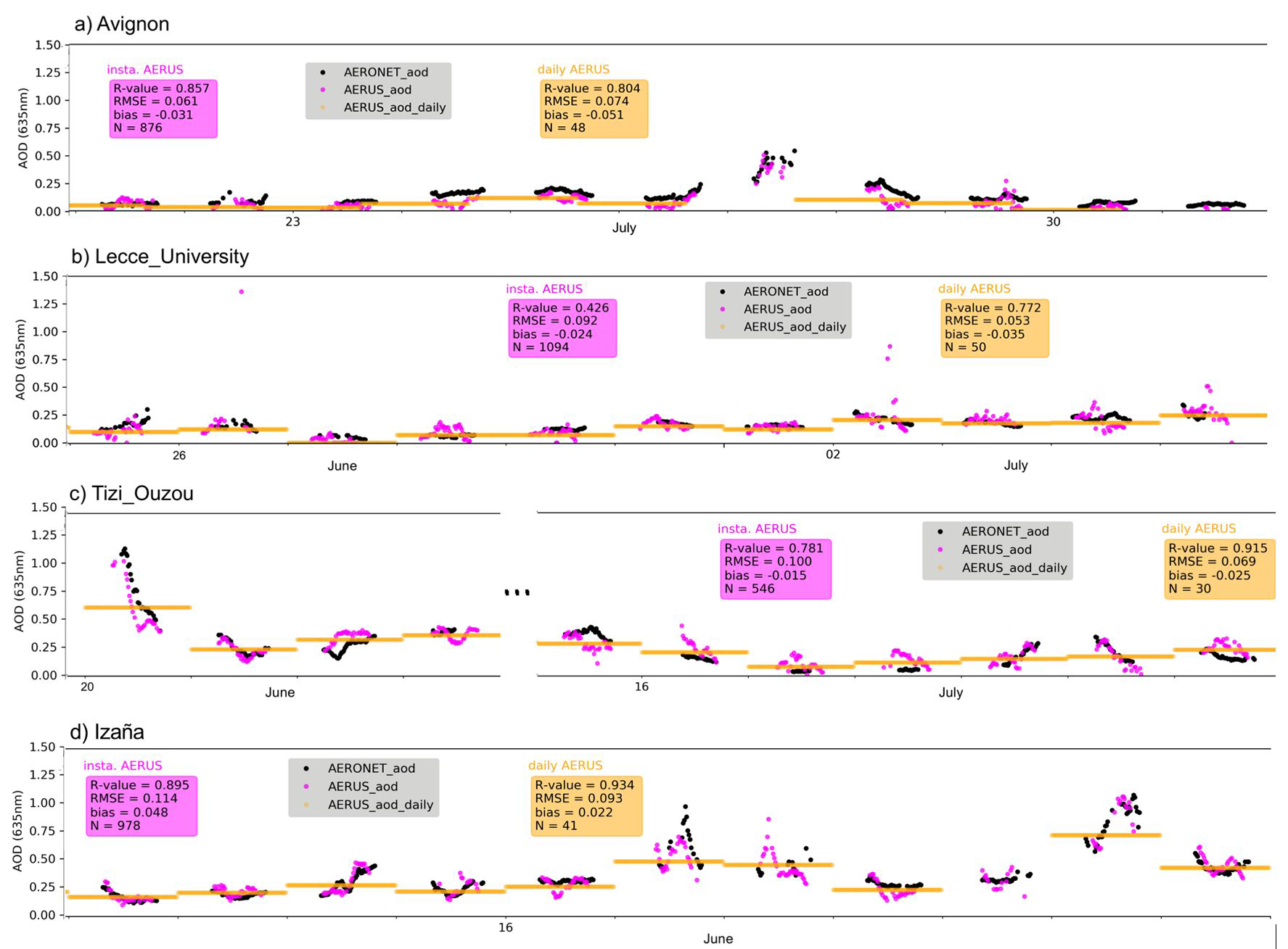
Figure 3 Time series of 15-min AOD values from i-AERUS-GEO and AERONET over (a) Avignon, (b) Lecce_University, (c) Tizi_Ouzou, and (d) Izaña in magenta and black, respectively. Daily averages of AOD provided by the daily AERUS-GEO algorithm are also shown in orange.
After finalizing the development and testing of i-AERUS-GEO for MSG, the next goal will be to adapt it to the future FCI sensor aboard the MTG-I platform operated by EUMETSAT (launch scheduled for 2022), which will provide unprecedented performances to detect and characterize atmospheric aerosols from the GEO orbit.
Data Policy
The AERUS-GEO products distributed by ICARE are public and free of charge.
Publications using AERUS-GEO products must include the following sentence:
AERUS-GEO products was developed in the framework of a joint collaboration between AERIS/ICARE Data and Services Center, EUMETSAT, and CNRM/Météo-France. Products are generated and distributed by AERIS/ICARE Data and Services Center (https://www.icare.univ-lille.fr)”
Short credit:
CNRM/Météo-France/EUMETSAT/AERIS/ICARE
Contacts
For more information regarding product access, registration, or any technical information, please contact icare-contact@univ-lille.fr
For science questions about the AERUS-GEO products, please contact:
Xavier Ceamanos (Principal Investigator at CNRM)
Current and former contributors
ICARE: Bruno Six, Sylvain Neut, Jacques Descloitres, Jérôme Riedi
CNRM: Xavier Ceamanos, Dominique Carrer, Suman Moparthy, Jean-Louis Roujean
References
[1] Carrer, D., Ceamanos, X., Six, B., and Roujean, J.-L. (2014), AERUS-GEO: a newly available satellite-derived aerosol optical depth product over Europe and Africa, GRL, 41, 7731-7738.
[2] Carrer, D., Roujean, J.-L., Hautecoeur, 0., and Elias, T., (2010), Daily estimates of aerosol optical thickness over land surface based on a directional and temporal analysis of SEVIRI MSG visible observations, Journal of Geophysical Research-Atmospheres, Vol. 115, D10208.
[3] H. Xu, X. Ceamanos, J.-L. Roujean, D. Carrer, and Y. Xue, Can satellite-derived aerosol optical depth quantify the surface aerosol radiative forcing? Atmospheric Research, Vol. 150, Dec. 2014, pp. 151-167
[4] Ceamanos, X., Moparthy, S., Carrer, D., Seidel, F.C: Assessing the Potential of Geostationary Satellites for Aerosol Remote Sensing Based on Critical Surface Albedo. Remote Sens., 11, 2958, 2019a
[5] Ceamanos, X., Moparthy, S., Carrer, D., Six, B.: Retrieving the diurnal cycle of aerosol optical depth from current and future Meteosat geostationary satellites, AGU Fall Meeting, oral, Dec. 2019b