This category is a gallery of the images of the month
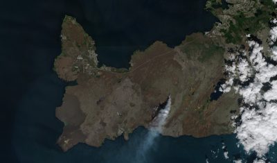
Volcanic eruption in Iceland July 2023
A volcanic eruption started on July 10, 2023 on the Reykjanes Peninsula in Iceland, in a remote area located about 30 km southwest of Reykjavik. A large flow of lava emerged from a crack that had just torn open over 900 meters in the bedrock. It filled the air with toxic gases and smoke for […]
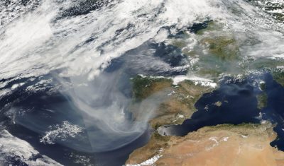
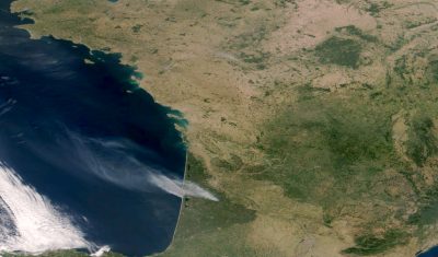
Smoke from Canadian wildfires reaches Western Europe June 27, 2023
On June 27, 2023, huge amounts of smoke coming from the west hovered above part of Western Europe. That smoke was released a few days earlier by severe wildfires raging in Eastern Canada. The smoke traveled high in the atmosphere thousands of kilometers across the Atlantic Ocean. The smoke plume reached the coast of Portugal […]
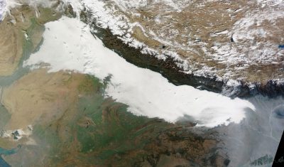
Dense fog in Northern India, January 2023
For several days in January 2023, Northern India, including the capital city New Delhi, struggled with a persistent thick fog and a severe cold wave with temperatures down to 1.5° C in some places, well below normal level. Although it is common for thick fog and haze to build up during the cold months in this region, it was particularly thick […]
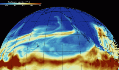
DROWN BY THE RIVER …
In late December 2022 and for most of January 2023 an atmospheric river (yellow plume over North Pacific Ocean) transported vast amount of water vapor from the tropical belt across Pacific up to west coast of North America, leading to record precipitations in California especially when it combined with the extreme event that developed on […]
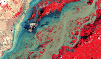
Floods in Pakistan August 2022
Torrential monsoon rains and record glacier melting caused by a severe heat wave triggered devastating flooding in Pakistan. The peak of flooding was reached in early September, leaving 8000 km2 of the Sindh province under several meters of water across a 100 km distance. Over hundreds of kilometers, the Indus River became a gigantic river over […]
Wildfires in southwest France July 2022
The VIIRS sensor on board NASA/NOAA’s Suomi-NPP satellite captured this true-color image showing wildfires raging in southwest France in La Teste-de-Buch (left) and Landiras (right) on July 18, 2022 at 13:30 UTC. Close-ups show those 2 wildfires observed by the MSI sensor on board Copernicus’s Sentinel-2B satellite on July 17, 2022 at 11:09 UTC. Source: […]
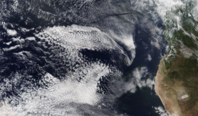
A zoo in a cloudy sky
Look !! A bunny ! Remember when as a kid you would star at the sky finding rabbit shaped clouds and all sorts of other fluffy animals … Well that’s exactly what Camilla, one of our recent visitor from a neighbour college did. As she was browsing through satellite imagery on Worldview, Camilla ran into […]
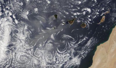
Von Karman vortices off the Canary Islands
This remarkable phenomenon easily visible from satellite and called Von Karman vortices, occurs under particular conditions of wind and terrain relief. It is commonly observed downwind of the Canary Islands when sustained trade winds blow through the islands (from the northeast to the southwest). The island relief disrupts the air flow, deflecting it around on each side. As the air flow passes […]
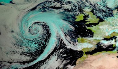
Low-pressure system over the North Atlantic Ocean
Source:EUMETSAT/AERIS/SATMOS/ICARE Move the white slider to compare images The false color composite can be compared to the corresponding SEVIRI image at 6.7 microns that enhances water vapor content in mid- to upper-troposphere. Brighter gray shades indicate greater water vapor content (including clouds when relative humidity reaches 100%). Dark gray shades indicate dry air. Source:EUMETSAT/AERIS/SATMOS/ICARE Déplacer […]