ICARE developed a variety of tools to help users manipulate, analyze and visualize the data sets and formats available at ICARE.
MSG NATIVE2HDF: Extract and save into HDF file IR or VIS MSG data
Language/Sofware: IDL
Application type(s): Data Conversion
Related project(s): MSG
Description:
This application reads IR or VIS channels in the native MSG format and dump them into a HDF file. It can also compute brightness temperatures for IR channels.
Author(s): Franck Gabarrot (ICARE)
Hdf2img: Creation an image from a HDF4 SDS
Language/Sofware: Numpy, PIL, Python
Application type(s): Data Conversion, Visualization
Related project(s):
Description:
This application creates an image of a 2D HDF4 SDS. It supports different colormaps, min/max thresholding, scaling, fill value filtering…
Many output image formats are also supported.
Author(s): Nicolas Pascal (ICARE)
Hdf tools : HDF4 data format conversion tools
Language/Sofware: C
Application type(s): Data Conversion
Related project(s): Megha-Tropiques
Description:
This package contains some tools for manipulating HDF4 files :
– hdf2raw : write a HDF4 SDS to a binary file
– raw2hdf : write a 2D binary data to a HDF4 file
– ncf2hdf : convert a NETCDF file to an HDF one
Author(s): Bruno Six, Jacques Descloitres, Nicolas Pascal (ICARE)
HDF compressor: Useful tool for compressing a HDF4 file
Language/Sofware: C++
Application type(s): Data Conversion
Related project(s):
Description:
This tool compress the datasets of a source HDF4 file using a gzip algorithm to a destination one. It also duplicates the SDS and file attributes.
Author(s): Nicolas Pascal (ICARE)
Geostat: Navigation routines for some geostationary satellites ( METEOSAT, GOES, MSG )
Language/Sofware: C, Fortran
Application type(s): Data Read/Write
Related project(s): GOES, METEOSAT, MSG
Description:
A set of routines to compute latitudes, longitudes, azimutal and zenithal angles from rows and columns in the satellite grid (and the reverse)
Author(s): C wrapper : Fabrice Ducos ( ICARE – LOA – Univ. of Lille ) ; FORTRAN Library developped by SATMOS and supplied by Geneviève Sèze ( LMD )
Fis2raw: A tool to convert the FIS format (from the SATMOS, at Lannion) into a simple, headerless, raw binary file
Language/Sofware: C
Application type(s): Data Conversion
Related project(s): MSG
Description:
The FIS format is a data format provided in particular by the SATMOS Archivage Center, at Lannion (MSG data at Lannion are archived this way). The program fis2raw converts the FIS format into a raw, headerless, binary file. The number of values and their type may be retrieved while performing the conversion.
Author(s): Fabrice Ducos (ICARE – LOA – Univ. of Lille)
Xrit2raw: A tool to convert XRIT/SEVIRI data into a simple, headerless, raw binary file (along with libxrit, the library xrit2raw is based upon)
Language/Sofware: C
Application type(s): Data Conversion
Related project(s): MSG
Description:
xrit2raw is a simple tool designed above the libxrit library, in order to convert the XRIT format into a raw format, for people who don’t want to bother themselves with programming. The output will be a simple, headerless binary file, with 3712×3712 values of radiances for the low resolution channels, or with 11136×11136 values for the high resolution channel HRV (in native 16-bit integer, or scaled simple or double precision floating point values, depending on the options set by the user).
Author(s): Fabrice Ducos (ICARE – LOA – Univ. of Lille)
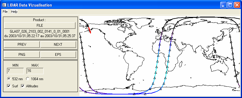
VISU GLAS: Visualisation of GLAS data and products through a graphic interface
Language/Sofware: IDL
Application type(s): Visualization
Related project(s): GLAS
Description:
Tool for visualising several GLAS ( Geoscience Laser Altimeter System ) data products through a graphic interface. Allows geographical selection, thresholding, export to images…
Author(s): Bruno Six (ICARE)
VISU CALIOP: Visualisation of CALIOP data and products through a graphic interface
Language/Sofware: IDL
Application type(s): Visualization
Related project(s): CALIPSO
Description:
Tool for visualising several CALIOP data products through a graphic interface. Allows geographical selection, thresholding, export to images…
Author(s): Bruno Six (ICARE)