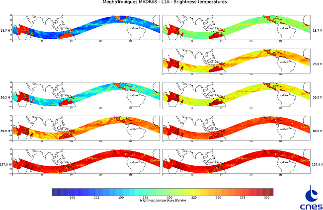
Megha-Tropiques satellite acquires first MADRAS and SAPHIR images on October 25, 2011

The MADRAS and SAPHIR instruments onboard the Megha-Tropiques satellite have captured their first image on October 15, 2011. The CNES has processed the MADRAS 9 channels and SAPHIR 6 channels to generate geolocated brightness temperature on one orbit.

This image is an example taken by the MADRAS instrument (Microwave Analysis and Detection of Rain and Atmospheric Structures). It shows one orbit of brightness temperature passing over Central Africa, Northern Australia, and Central America.

More news

Highlights

AERIS/ICARE was migrated his good old FTP server to SFTP

For security reason, we are abandoning the FTP protocol in favor of SFTP on our distribution server. Depending of the way you are using this service, you can have to change the commands you are used to. Note that not all applications support the SFTP protocol, and some additional tools may need to be installed […]

01.03.2024

Highlights

Data Summary Announcement for the release of the CALIPSO Lidar Level 2 Blowing Snow – Antarctica Version 2.00 and Greenland Version 1.00 Products

Data Release Date: January 29, 2024Version: Antarctica – Version 2.00 and Greenland – Version 1.00Data Date Range: June 13, 2006 to June 30, 2023 The CALIPSO mission team announces the release of two new CALIOP Level 2 monthly data products: The Blowing Snow monthly data products, developed by Dr. Stephen Palm, isolates blowing snow events determined from the […]

05.02.2024

Highlights

Data Summary Announcement for the release of the CALIPSO IIR Level 2 Products Version 4.51

Data Release Date: September 25, 2023Version: 4.51Data Date Range: June 13, 2006 to June 30, 2023 The CALIPSO mission team announces the release of new IIR Level 2 Products: The V4.51 IIR Level 2 track and swath products use the recently released V4.51 CALIOP Level 2 layer products. Data are produced and successfully ingested at the Atmospheric Science […]

16.10.2023

Search