
New product announcement: Release of POLAC wind speed product derived from POLDER/PARASOL observations– May 2016
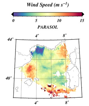
Image credit: Harmel and Chami (2012)
A wind speed product has been developed in the framework of a joint collaboration between the Laboratoire d’Océanographie de Villefranche (France) and ICARE. This new product is derived from POLDER/PARASOL polarimetric and multidirectional observations over the oceans using an algorithm named POLAC (POLarized Atmospheric Correction) and a method based on the dependence of the Sun glint radiation on wind speed. The wind speed is given at full PARASOL native spatial resolution (about 6 km at nadir) on a pixel basis, and in HDF format for each orbit (POLAC-L2 “Level-2”) or daily (e.g. globally, POLAC-D3 “Level-3”). The Level-2 and Level-3 products are public. Click here for the Level-2 or here for the daily Level-3 to access the data from the ICARE archive interface. The current version is v1.00, with data processed from March 2005 to October 2013.
For a summary description of the method, see the POLAC document. Detailed description of the algorithm and validation studies using in-situ and satellite data are available in Harmel and Chami, 2011, 2012 and 2013 (see Publications).
This image shows an example of wind speed values retrieved from the PARASOL image acquired on May 5, 2006 over the north-west part of the Mediterranean Sea (from Fig. 1a, Harmel and Chami (2012)).
+ Access to POLAC Level-2 products from the ICARE on-line archive
+ Access to POLAC Level-3 products from the ICARE on-line archive