Privacy Overview
This website uses cookies to improve your experience while you navigate through the website. Out of these cookies, the cookies that are categorized as necessary are stored on your browser as they are essential for the working of basic functionalities of the website. We also use third-party cookies that help us analyze and understand how you use this website. These cookies will be stored in your browser only with your consent. You also have the option to opt-out of these cookies. But opting out of some of these cookies may have an effect on your browsing experience.
Always Active

Necessary cookies are required to enable the basic features of this site, such as providing secure log-in or adjusting your consent preferences. These cookies do not store any personally identifiable data.

No cookies to display.

Functional cookies help perform certain functionalities like sharing the content of the website on social media platforms, collecting feedback, and other third-party features.

No cookies to display.

Analytical cookies are used to understand how visitors interact with the website. These cookies help provide information on metrics such as the number of visitors, bounce rate, traffic source, etc.

No cookies to display.

Performance cookies are used to understand and analyze the key performance indexes of the website which helps in delivering a better user experience for the visitors.

No cookies to display.

Advertisement cookies are used to provide visitors with customized advertisements based on the pages you visited previously and to analyze the effectiveness of the ad campaigns.

No cookies to display.

New product announcement: Release of SEVIRI AERUS-GEO aerosol product – January 2015

MSG/SEVIRI AERUS AOD 0.63 µm observed by SEVIRI
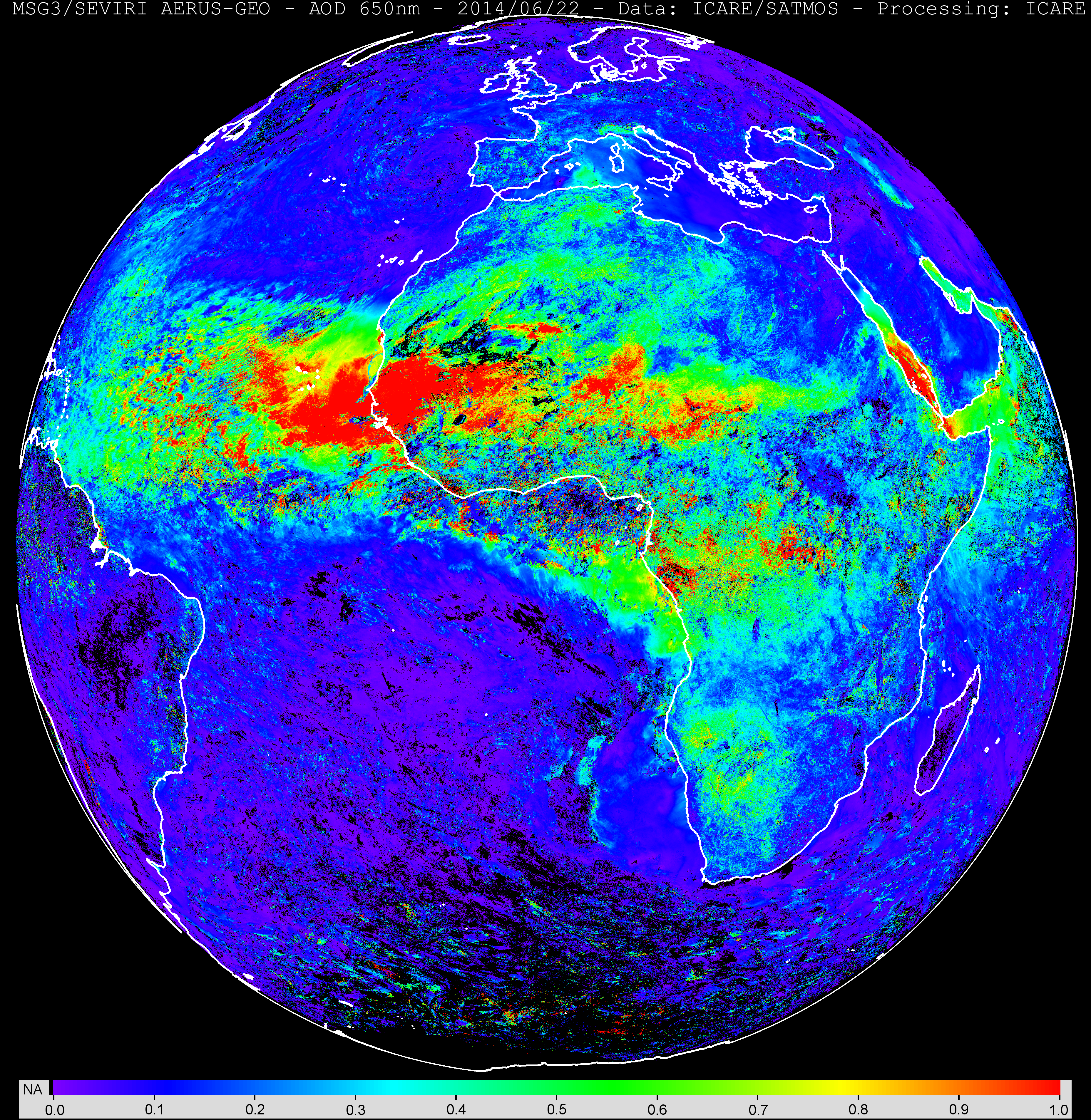
Image credit: CNRM-GAME/ICARE.

A new SEVIRI aerosol product has been developed in the framework of a joint collaboration between Meteo France (CNRM-GAME) and ICARE. The new daily (daytime) aerosol optical depth product (SEV_AERUS-AEROSOL-NRT-D3) is public (click here to access the data from the archive interface (current version: v1.01, year 2014 until present)).
The AERUS-GEO (Aerosol and surface albEdo Retrieval Using a directional Splitting method-application to GEOstationary data) product is derived from observations from the Meteosat Second Generation (MSG) geostationary satellite covering Europe, Africa, and part of Asia and South America. The retrieval method exploits the directional information contained in the series of 96 MSG observations per day of the Earth’s disk to derive a daily mean AOD and an Angström exponent. Detailed description of the algorithm and evaluation studies are available in Carrer et al. 2010 (JGR) and Carrer el al., 2014 (see Publications). A reprocessing of the whole SEVIRI archive (2004-present) will be available soon.

This image shows an example of the retrieved aerosol optical depth during a dust storm event over West Africa on June 22, 2014. Click here for the full resolution image or here for the ICARE geostationary browse interface.

More news

Highlights

AERIS/ICARE was migrated his good old FTP server to SFTP

For security reason, we are abandoning the FTP protocol in favor of SFTP on our distribution server. Depending of the way you are using this service, you can have to change the commands you are used to. Note that not all applications support the SFTP protocol, and some additional tools may need to be installed […]

01.03.2024

Highlights

Data Summary Announcement for the release of the CALIPSO Lidar Level 2 Blowing Snow – Antarctica Version 2.00 and Greenland Version 1.00 Products

Data Release Date: January 29, 2024Version: Antarctica – Version 2.00 and Greenland – Version 1.00Data Date Range: June 13, 2006 to June 30, 2023 The CALIPSO mission team announces the release of two new CALIOP Level 2 monthly data products: The Blowing Snow monthly data products, developed by Dr. Stephen Palm, isolates blowing snow events determined from the […]

05.02.2024

Highlights

Data Summary Announcement for the release of the CALIPSO IIR Level 2 Products Version 4.51

Data Release Date: September 25, 2023Version: 4.51Data Date Range: June 13, 2006 to June 30, 2023 The CALIPSO mission team announces the release of new IIR Level 2 Products: The V4.51 IIR Level 2 track and swath products use the recently released V4.51 CALIOP Level 2 layer products. Data are produced and successfully ingested at the Atmospheric Science […]

16.10.2023

Search