Eruption of Hunga Tonga volcano in the South Pacific ocean January 15, 2022


Source: JMA/AERIS/SATMOS/ICARE
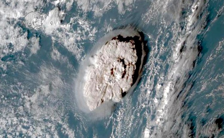
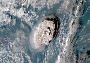
On January 15, 2022, in the late afternoon (January 15, 04:10 Universal Time), Hunga Tonga, an underwater volcano located in the Tonga archipelago southeast of Fidji in the South Pacific ocean, dramatically erupted, destroying the small Hunga Tonga — Hunga Ha’apai island. The island bore that name since the lava flow of the 2015 eruption formed new land that joined the two islands Hunga Tonga and Hunga Ha’apai.
The eruption is the most powerful in the world in the past 3 decades. The island literally exploded. The eruption was indeed extremely violent, forming in just 30 minutes a giant umbrella-shaped ash plume of 300 km in diameter, and lofting ash and volcanic gas above 30 km in the atmosphere. The eruption scattered ash in the ocean all around and blanketed the neighboring islands with thick ash.
This spectacular eruption caused an atmospheric shockwave and was heard 9,360 kilometers away in Alaska at 12:30 UTC (i.e. about 8.3 hours later). Simultaneously, the eruption triggered a series of tsunami waves across the Pacific Ocean up to 10,000 km away, impacting the coasts of Chile, the United States and Japan.
Early reports suggest that local residents are significantly impacted by the ash and tsunami waves caused by the eruption.
Sensors on board satellites captured the eruption and the huge plume of ash reaching the stratosphere.
Source: NOAA/NASA/AERIS/ICARE
Source: JMA/AERIS/SATMOS/ICARE
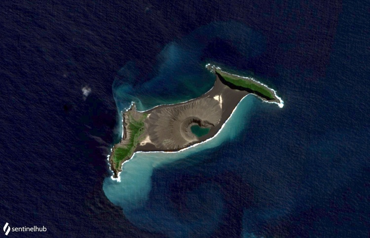
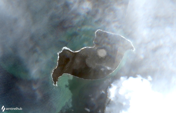

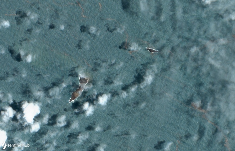
The Multispectral Instrument (MSI) on board ESA/Copernicus’s Sentinel-2 satellite captured high-resolution imagery. The true-color images shown above are built with bands 4 (665 nm), 3 (560 nm) and 2 (490 nm).The top pair of images compares the shape of the volcano on August 30, 2021 and on January 2, 2022, right after volcanic activity that occurred in December 2021, which substantially reshaped the island. The bottom pair of images (Left: January 2, 2022, before the eruption; Right: January 17, 2022, right after the eruption) shows how the January 15, 2022 eruption completely disintegrated the island, leaving two tiny reminders of the island that once existed. The central part of the island, formed by previous eruptions, including the volcano crater, completely disappeared. In the bottom right image, the turquoise color of the water is caused by fine ash particles fallout that formed a giant sediment plume, extending as far as 100 km around the volcano (beyond the image shown)
Source: JMA/AERIS/SATMOS/ICARE
Le 15 janvier 2022 en fin d’après-midi (15 janvier, 04h10 temps universel), Hunga Tonga, un volcan sous-marin de l’archipel des Tonga au sud-est des Fidji dans le Pacifique Sud, est entré en éruption de façon spectaculaire, détruisant la petite île de Hunga Tonga – Hunga Ha’apai. L’île portait ce nom depuis que l’éruption de 2015 avait formé une nouvelle terre rejoignant les deux îles Hunga Tonga et Hunga Ha’apai.
Cette éruption est la plus puissante des 3 dernières décennies au niveau mondial. L’île a littéralement explosé. L’éruption a été extrêmement violente, formant en seulement 30 minutes un panache de cendres géant en forme de parapluie de 300 km de diamètre, et projetant des cendres et des gaz volcaniques à plus de 30 km dans l’atmosphère. L’éruption a dispersé des cendres dans l’océan tout autour et a recouvert les îles voisines d’une épaisse couche de cendres.
Cette éruption spectaculaire a provoqué une onde de choc atmosphérique et a été entendue à 9360 kilomètres en Alaska à 12:30 UTC (environ 8.3 heures plus tard). Simultanément, l’éruption a déclenché une série de tsunamis à travers l’océan Pacifique jusqu’à 10 000 km de distance, frappant les côtes du Chili, des États-Unis et du Japon.
Les informations préliminaires rapportent que les résidents locaux sont considérablement touchés par les dépôts de cendres et les tsunamis causés par l’éruption.
Des capteurs à bord des satellites fournissent des observations de l’éruption et de l’énorme panache de cendres éjecté dans la stratosphère.
Source: NOAA/NASA/AERIS/ICARE
Source: JMA/AERIS/SATMOS/ICARE
L’instrument multispectral MSI à bord du satellite Sentinel-2 d’ESA/Copernicus fournit des images à haute résolution. Les images en vraies couleurs présentées ci-dessus sont construites avec les bandes 4 (665 nm), 3 (560 nm) et 2 (490 nm). La paire d’images du haut compare la forme du volcan du 30 août 2021 et du 2 janvier 2022, juste après l’activité volcanique qui s’est produite en décembre 2021 qui a considérablement remodelé l’île. La paire d’images du bas (à gauche : 2 janvier 2022, avant l’éruption ; à droite : 17 janvier 2022, juste après l’éruption) montre comment l’éruption du 15 janvier 2022 a complètement désintégré l’île, laissant deux petites bandes de terre de l’île qui existait auparavant. La partie centrale de l’île, formée par les éruptions précédentes, y compris le cratère du volcan, a complètement disparu. Dans l’image en bas à droite, la couleur turquoise de l’eau est due aux fines particules de cendres en suspension dans l’eau, formant une immense étendue de sédiments qui s’étend jusqu’à 100 km autour du volcan (au-delà de l’image montrée).