Privacy Overview
This website uses cookies to improve your experience while you navigate through the website. Out of these cookies, the cookies that are categorized as necessary are stored on your browser as they are essential for the working of basic functionalities of the website. We also use third-party cookies that help us analyze and understand how you use this website. These cookies will be stored in your browser only with your consent. You also have the option to opt-out of these cookies. But opting out of some of these cookies may have an effect on your browsing experience.
Always Active

Necessary cookies are required to enable the basic features of this site, such as providing secure log-in or adjusting your consent preferences. These cookies do not store any personally identifiable data.

No cookies to display.

Functional cookies help perform certain functionalities like sharing the content of the website on social media platforms, collecting feedback, and other third-party features.

No cookies to display.

Analytical cookies are used to understand how visitors interact with the website. These cookies help provide information on metrics such as the number of visitors, bounce rate, traffic source, etc.

No cookies to display.

Performance cookies are used to understand and analyze the key performance indexes of the website which helps in delivering a better user experience for the visitors.

No cookies to display.

Advertisement cookies are used to provide visitors with customized advertisements based on the pages you visited previously and to analyze the effectiveness of the ad campaigns.

No cookies to display.

Recent progress of the AERUS-GEO project for global observation of aerosols from geostationary satellites

Over past years CNRM has developed with support from AERIS/ICARE the AERUS-GEO suite of Aerosols and Surface properties products (https://www.icare.univ-lille.fr/projects/user-driven-projects/aerus-geo/).

Initially aimed at providing a daily averaged Aerosol Optical Depth (AOD) from SEVIRI sensors aboard the MSG satelliteseries, the project is now about to provide retrievals of aerosol properties at 15-min intervals thanks to the new i-AERUS-GEO algorithm (currently under validation).

Also, thanks to the GEO archive maintained at AERIS/ICARE we are currently developing a full GEO-ring AERUS-GEO product whereby merging the observations of imagers on five geostationary platforms (MSG-0°, MSG-41,5°E, HIMAWARI, GOES-E and GOES-W) we can derive aerosol properties over the quasi-global zone covered by meteorological operational geostationary satellites.

We present here a first snapshot of the product currently under development. The image below illustrates the five GEO imagers used for the product and presents the daily average AOD obtained for August 31, 2020 superimposed on a false color composite image derived from the surface albedo derived by AERUS-GEO for the corresponding period. 
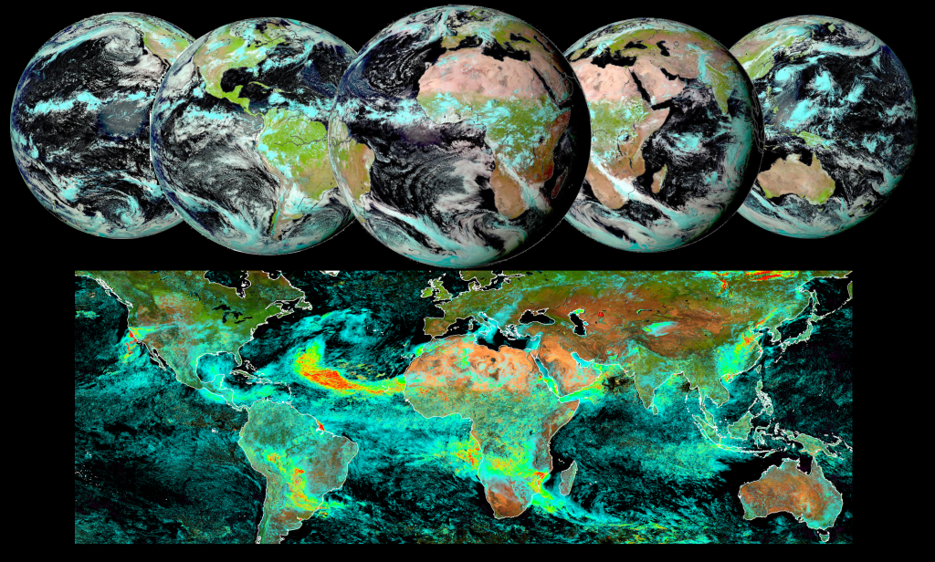
The animation available below illustrates the daily average AOD obtained from August 10, 2020 to August 31, 2020. A striking massive aerosol dust event blowing out of Sahara and transported aloft the Atlantic Ocean is clearly visible from the animation as well as wild fires in California and other noticeable aerosols plumes all over the globe. 

Once in full production mode at AERIS/ICARE, the AERUS-GEO products developed by CNRM & ICARE will provide 15-min global aerosol properties from the GEO ring.

A first example of global retrievals obtained from February to November 2020 illustrates below the interest of multiple GEO to follow the emission and dispersion of aerosols worldwide.

With the increasing availability of more advanced GEO sensors and once Meteosat Third Generation becomes available, the AERUS-GEO products will provide an unprecedented source of information for global monitoring of aerosols and air quality worldwide.

Find more information about AERUS-GEO here:https://www.icare.univ-lille.fr/projects/user-driven-projects/aerus-geo/

The AERUS-GEO project has been developed with support from CNES, CNRS and EUMETSAT

Image and Video credits : AERIS/ICARE – CNRM – 2020

More news

Highlights

AERIS/ICARE was migrated his good old FTP server to SFTP

For security reason, we are abandoning the FTP protocol in favor of SFTP on our distribution server. Depending of the way you are using this service, you can have to change the commands you are used to. Note that not all applications support the SFTP protocol, and some additional tools may need to be installed […]

01.03.2024

Highlights

Data Summary Announcement for the release of the CALIPSO Lidar Level 2 Blowing Snow – Antarctica Version 2.00 and Greenland Version 1.00 Products

Data Release Date: January 29, 2024Version: Antarctica – Version 2.00 and Greenland – Version 1.00Data Date Range: June 13, 2006 to June 30, 2023 The CALIPSO mission team announces the release of two new CALIOP Level 2 monthly data products: The Blowing Snow monthly data products, developed by Dr. Stephen Palm, isolates blowing snow events determined from the […]

05.02.2024

Highlights

Data Summary Announcement for the release of the CALIPSO IIR Level 2 Products Version 4.51

Data Release Date: September 25, 2023Version: 4.51Data Date Range: June 13, 2006 to June 30, 2023 The CALIPSO mission team announces the release of new IIR Level 2 Products: The V4.51 IIR Level 2 track and swath products use the recently released V4.51 CALIOP Level 2 layer products. Data are produced and successfully ingested at the Atmospheric Science […]

16.10.2023

Search